Inabanga geodata
Inabanga (Central Visayas) is a seat of a third-order administrative division; located in Philippines in Asia/Manila (GMT+8) time zone. In our database, there are 4166 cities with bigger population. Compared to other cities in Philippines, 68% of cities are located further ↑North; 72.4% of cities are located further ←West and 98.8% of cities have higher elevation than Inabanga. Note1


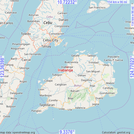
Inabanga GPS coordinates[2]
10° 1' 50.52" North, 124° 4' 1.56" East
| Map corner | latitude | longitude |
|---|---|---|
| Upper-left | 10.72232°, | 123.36398° |
| Center: | 10.0307°, | 124.0671° |
| Lower-right: | 9.3376°, | 124.77023° |
| Map W x H: | 154×154 km | = 95.7×95.7mi |
| max Lat: | 20.78733° ⇑68% North |
| Inabanga: | 10.0307° |
| min Lat: | ⇓32% South 4.65442° |
| min Long | Inabanga | max Long |
| 117.04868° | 124.0671° | 126.58417° |
| W 72.4%⇐ | ⇒27.6% E |
Elevation
Elevation of Inabanga is 2 m = 7 ft, and this is 85.9 m = 282 ft below average elevation for this country.
| Max E: |
2262 m = 7421 ft | 98.8% |
| Avg. | 87.9 m = 288 ft | |
| Inabanga | 2 m = 7 ft | |
Min E: |
-2 m = -7 ft | 1.2% |
See also: Philippines elevation on elevation.city.
Geographical zone
Inabanga is located in North Torrid zone (between Equator and Tropic of Cancer). Distance of Equator is 1115.3 km =693 mi to South.| Distance of | km | miles | from Inabanga |
|---|---|---|---|
| North Pole | 8891.8 | 5525.1 | to North |
| Arctic Circle | 6285.9 | 3905.9 | to North |
| Tropic Cancer | 1490.6 | 926.2 | to North |
| Equator | 1115.3 | 693 | to South |


Nearby cities:
15 places around Inabanga: (largest is in red/bold)
• Abucayan
20.2 km =12.6 mi,  235°
235°
• Buenavista
7.9 km =4.9 mi,  42°
42°
• Cabul-an
14.3 km =8.9 mi,  349°
349°
• Canmaya Diot
10.7 km =6.6 mi,  163°
163°
• Catigbian
21.4 km =13.3 mi,  200°
200°
• Clarin
8.9 km =5.5 mi,  210°
210°
• Danao
19.6 km =12.2 mi,  119°
119°
• Jandayan Norte
19.8 km =12.3 mi, 39°
• Jetafe
16.1 km =10 mi, 36°
• Nahawan
6.9 km =4.3 mi, 197°
• Nueva Fuerza
23.2 km =14.4 mi,  151°
151°
• Panaytayon
12.8 km =8 mi,  225°
225°
• Pinayagan Norte
16.8 km =10.4 mi, 229°
• Sagbayan
13.2 km =8.2 mi,  168°
168°
• Tibigan
14.5 km =9 mi, 232°
Sources, notices
• [Note1] Compared only with cities in Philippines existing in our database
• [Src1] Map data: © OpenStreetMap contributors (CC-BY-SA)
• [Src2] Other city data from geonames.org with taken over terms of usage.
• [Src3] Geographical zone / Annual Mean Temperature by Robert A. Rohde @ Wikipedia
