San Roque geodata
San Roque (Central Visayas) is a populated place; located in Philippines in Asia/Manila (GMT+8) time zone. With population of 2,580 people, there are 3143 cities with bigger population in this country. Compared to other cities in Philippines, 67.5% of cities are located further ↑North; 76% of cities are located further ←West and 76.6% of cities have higher elevation than San Roque. Note1


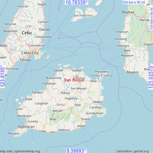
San Roque GPS coordinates[2]
10° 5' 30.84" North, 124° 19' 21.432" East
| Map corner | latitude | longitude |
|---|---|---|
| Upper-left | 10.78339°, | 123.6195° |
| Center: | 10.0919°, | 124.32262° |
| Lower-right: | 9.39893°, | 125.02575° |
| Map W x H: | 153.9×153.9 km | = 95.6×95.6mi |
| max Lat: | 20.78733° ⇑67.5% North |
| San Roque: | 10.0919° |
| min Lat: | ⇓32.5% South 4.65442° |
| min Long | San Roque | max Long |
| 117.04868° | 124.32262° | 126.58417° |
| W 76%⇐ | ⇒24% E |
Elevation
Elevation of San Roque is 10 m = 33 ft, and this is 77.9 m = 256 ft below average elevation for this country.
| Max E: |
2262 m = 7421 ft | 76.6% |
| Avg. | 87.9 m = 288 ft | |
| San Roque | 10 m = 33 ft | |
Min E: |
-2 m = -7 ft | 23.4% |
See also: Philippines elevation on elevation.city.
Geographical zone
San Roque is located in North Torrid zone (between Equator and Tropic of Cancer). Distance of Equator is 1122.1 km =697.2 mi to South.| Distance of | km | miles | from San Roque |
|---|---|---|---|
| North Pole | 8884.9 | 5520.8 | to North |
| Arctic Circle | 6279.1 | 3901.7 | to North |
| Tropic Cancer | 1483.8 | 922 | to North |
| Equator | 1122.1 | 697.2 | to South |


Nearby cities:
15 places around San Roque: (largest is in red/bold)
• Bagacay
9.7 km =6 mi,  313°
313°
• Bien Unido
7.9 km =4.9 mi,  50°
50°
• Calituban
16.8 km =10.4 mi,  348°
348°
• Camambugan
13.2 km =8.2 mi,  106°
106°
• Hinlayagan Ilaud
6.9 km =4.3 mi,  169°
169°
• Jandayan Norte
17.6 km =10.9 mi,  298°
298°
• Jetafe
19.5 km =12.1 mi,  288°
288°
• Mahayag
17.5 km =10.9 mi,  182°
182°
• San Francisco
7.7 km =4.8 mi, 350°
• San Miguel
11.8 km =7.3 mi, 170°
• San Pascual
19.3 km =12 mi,  142°
142°
• Tagum Norte
7.5 km =4.7 mi,  104°
104°
• Talibon
6.4 km =4 mi,  2°
2°
• Trinidad
2.6 km =1.6 mi,  121°
121°
• Ubay
16.9 km =10.5 mi, 103°
Sources, notices
• [Note1] Compared only with cities in Philippines existing in our database
• [Src1] Map data: © OpenStreetMap contributors (CC-BY-SA)
• [Src2] Other city data from geonames.org with taken over terms of usage.
• [Src3] Geographical zone / Annual Mean Temperature by Robert A. Rohde @ Wikipedia
