San Francisco geodata
San Francisco (Central Visayas) is a populated place; located in Philippines in Asia/Manila (GMT+8) time zone. With population of 5,047 people, there are 1278 cities with bigger population in this country. Compared to other cities in Philippines, 66.6% of cities are located further ↑North; 75.8% of cities are located further ←West and 85.4% of cities have higher elevation than San Francisco. Note1


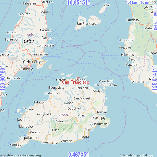
San Francisco GPS coordinates[2]
10° 9' 36.648" North, 124° 18' 39.528" East
| Map corner | latitude | longitude |
|---|---|---|
| Upper-left | 10.85151°, | 123.60786° |
| Center: | 10.16018°, | 124.31098° |
| Lower-right: | 9.46735°, | 125.01411° |
| Map W x H: | 153.9×153.9 km | = 95.6×95.6mi |
| max Lat: | 20.78733° ⇑66.6% North |
| San Francisco: | 10.16018° |
| min Lat: | ⇓33.4% South 4.65442° |
| min Long | San Francisco | max Long |
| 117.04868° | 124.31098° | 126.58417° |
| W 75.8%⇐ | ⇒24.2% E |
Elevation
Elevation of San Francisco is 8 m = 26 ft, and this is 79.9 m = 262 ft below average elevation for this country.
| Max E: |
2262 m = 7421 ft | 85.4% |
| Avg. | 87.9 m = 288 ft | |
| San Francisco | 8 m = 26 ft | |
Min E: |
-2 m = -7 ft | 14.6% |
See also: Philippines elevation on elevation.city.
Geographical zone
San Francisco is located in North Torrid zone (between Equator and Tropic of Cancer). Distance of Equator is 1129.7 km =702 mi to South.| Distance of | km | miles | from San Francisco |
|---|---|---|---|
| North Pole | 8877.4 | 5516.2 | to North |
| Arctic Circle | 6271.5 | 3896.9 | to North |
| Tropic Cancer | 1476.2 | 917.3 | to North |
| Equator | 1129.7 | 702 | to South |


Nearby cities:
15 places around San Francisco: (largest is in red/bold)
• Bagacay
5.8 km =3.6 mi,  261°
261°
• Bien Unido
7.7 km =4.8 mi,  109°
109°
• Buenavista
23 km =14.3 mi,  248°
248°
• Calituban
9.1 km =5.7 mi,  346°
346°
• Camambugan
17.9 km =11.1 mi,  129°
129°
• Hinlayagan Ilaud
14.6 km =9.1 mi,  169°
169°
• Jandayan Norte
14.2 km =8.8 mi,  273°
273°
• Jetafe
17.3 km =10.7 mi, 265°
• Mahayag
25.1 km =15.6 mi,  178°
178°
• San Miguel
19.5 km =12.1 mi, 170°
• San Roque
7.7 km =4.8 mi, 170°
• Tagum Norte
12.8 km =8 mi,  138°
138°
• Talibon
2 km =1.2 mi, 128°
• Trinidad
9.6 km =6 mi,  158°
158°
• Ubay
21.2 km =13.2 mi,  123°
123°
Sources, notices
• [Note1] Compared only with cities in Philippines existing in our database
• [Src1] Map data: © OpenStreetMap contributors (CC-BY-SA)
• [Src2] Other city data from geonames.org with taken over terms of usage.
• [Src3] Geographical zone / Annual Mean Temperature by Robert A. Rohde @ Wikipedia
