Cabul-an geodata
Cabul-an (Central Visayas) is a populated place; located in Philippines in Asia/Manila (GMT+8) time zone. With population of 3,850 people, there are 1809 cities with bigger population in this country. Compared to other cities in Philippines, 66.7% of cities are located further ↑North; 72% of cities are located further ←West and 99.6% of cities have higher elevation than Cabul-an. Note1


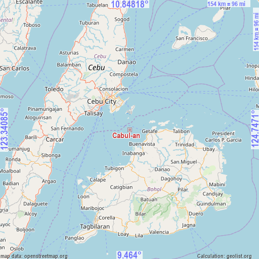
Cabul-an GPS coordinates[2]
10° 9' 24.624" North, 124° 2' 38.292" East
| Map corner | latitude | longitude |
|---|---|---|
| Upper-left | 10.84818°, | 123.34085° |
| Center: | 10.15684°, | 124.04397° |
| Lower-right: | 9.464°, | 124.7471° |
| Map W x H: | 153.9×153.9 km | = 95.6×95.6mi |
| max Lat: | 20.78733° ⇑66.7% North |
| Cabul-an: | 10.15684° |
| min Lat: | ⇓33.3% South 4.65442° |
| min Long | Cabul-an | max Long |
| 117.04868° | 124.04397° | 126.58417° |
| W 72%⇐ | ⇒28% E |
Elevation
Elevation of Cabul-an is 1 m = 3 ft, and this is 86.9 m = 285 ft below average elevation for this country.
| Max E: |
2262 m = 7421 ft | 99.6% |
| Avg. | 87.9 m = 288 ft | |
| Cabul-an | 1 m = 3 ft | |
Min E: |
-2 m = -7 ft | 0.4% |
See also: Philippines elevation on elevation.city.
Geographical zone
Cabul-an is located in North Torrid zone (between Equator and Tropic of Cancer). Distance of Equator is 1129.3 km =701.7 mi to South.| Distance of | km | miles | from Cabul-an |
|---|---|---|---|
| North Pole | 8877.7 | 5516.3 | to North |
| Arctic Circle | 6271.8 | 3897.1 | to North |
| Tropic Cancer | 1476.6 | 917.5 | to North |
| Equator | 1129.3 | 701.7 | to South |


Nearby cities:
15 places around Cabul-an: (largest is in red/bold)
• Adlaon
22.4 km =13.9 mi,  315°
315°
• Baugo
22.5 km =14 mi, 322°
• Buagsong
15.7 km =9.8 mi,  312°
312°
• Buenavista
11.4 km =7.1 mi,  135°
135°
• Clarin
21.8 km =13.5 mi,  185°
185°
• Cordova
14.8 km =9.2 mi, 311°
• Dapitan
15.6 km =9.7 mi, 318°
• Gabi
14.9 km =9.3 mi, 322°
• Inabanga
14.3 km =8.9 mi,  169°
169°
• Jandayan Norte
15.1 km =9.4 mi,  85°
85°
• Jetafe
12.1 km =7.5 mi,  95°
95°
• Lapu-Lapu City
20 km =12.4 mi,  328°
328°
• Mandaue City
22.8 km =14.2 mi, 324°
• Nahawan
20.7 km =12.9 mi,  178°
178°
• Tangke
22.4 km =13.9 mi,  299°
299°
Sources, notices
• [Note1] Compared only with cities in Philippines existing in our database
• [Src1] Map data: © OpenStreetMap contributors (CC-BY-SA)
• [Src2] Other city data from geonames.org with taken over terms of usage.
• [Src3] Geographical zone / Annual Mean Temperature by Robert A. Rohde @ Wikipedia
