Buenavista geodata
Buenavista (Central Visayas) is a seat of a third-order administrative division; located in Philippines in Asia/Manila (GMT+8) time zone. In our database, there are 4166 cities with bigger population. Compared to other cities in Philippines, 67.6% of cities are located further ↑North; 73.1% of cities are located further ←West and 76.6% of cities have higher elevation than Buenavista. Note1


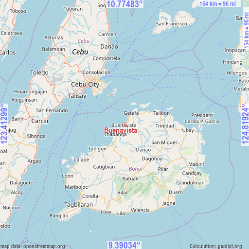
Buenavista GPS coordinates[2]
10° 4' 59.988" North, 124° 6' 57.996" East
| Map corner | latitude | longitude |
|---|---|---|
| Upper-left | 10.77483°, | 123.41299° |
| Center: | 10.08333°, | 124.11611° |
| Lower-right: | 9.39034°, | 124.81924° |
| Map W x H: | 153.9×153.9 km | = 95.6×95.6mi |
| max Lat: | 20.78733° ⇑67.6% North |
| Buenavista: | 10.08333° |
| min Lat: | ⇓32.4% South 4.65442° |
| min Long | Buenavista | max Long |
| 117.04868° | 124.11611° | 126.58417° |
| W 73.1%⇐ | ⇒26.9% E |
Elevation
Elevation of Buenavista is 10 m = 33 ft, and this is 77.9 m = 256 ft below average elevation for this country.
| Max E: |
2262 m = 7421 ft | 76.6% |
| Avg. | 87.9 m = 288 ft | |
| Buenavista | 10 m = 33 ft | |
Min E: |
-2 m = -7 ft | 23.4% |
See also: Philippines elevation on elevation.city.
Geographical zone
Buenavista is located in North Torrid zone (between Equator and Tropic of Cancer). Distance of Equator is 1121.2 km =696.7 mi to South.| Distance of | km | miles | from Buenavista |
|---|---|---|---|
| North Pole | 8885.9 | 5521.4 | to North |
| Arctic Circle | 6280 | 3902.2 | to North |
| Tropic Cancer | 1484.8 | 922.6 | to North |
| Equator | 1121.2 | 696.7 | to South |


Nearby cities:
15 places around Buenavista: (largest is in red/bold)
• Bagacay
17.4 km =10.8 mi,  63°
63°
• Cabul-an
11.4 km =7.1 mi,  315°
315°
• Canmaya Diot
16.3 km =10.1 mi,  188°
188°
• Clarin
16.8 km =10.4 mi,  216°
216°
• Danao
19.3 km =12 mi,  142°
142°
• Inabanga
7.9 km =4.9 mi, 222°
• Jandayan Norte
11.9 km =7.4 mi,  37°
37°
• Jetafe
8.2 km =5.1 mi,  30°
30°
• Nahawan
14.5 km =9 mi,  210°
210°
• Panaytayon
20.8 km =12.9 mi, 224°
• Sagbayan
19 km =11.8 mi, 188°
• San Francisco
23 km =14.3 mi,  68°
68°
• San Roque
22.6 km =14 mi,  87°
87°
• Talibon
24 km =14.9 mi, 72°
• Tibigan
22.3 km =13.9 mi,  229°
229°
Sources, notices
• [Note1] Compared only with cities in Philippines existing in our database
• [Src1] Map data: © OpenStreetMap contributors (CC-BY-SA)
• [Src2] Other city data from geonames.org with taken over terms of usage.
• [Src3] Geographical zone / Annual Mean Temperature by Robert A. Rohde @ Wikipedia
