Hinlayagan Ilaud geodata
Hinlayagan Ilaud (Central Visayas) is a populated place; located in Philippines in Asia/Manila (GMT+8) time zone. With population of 2,788 people, there are 2810 cities with bigger population in this country. Compared to other cities in Philippines, 68% of cities are located further ↑North; 76.3% of cities are located further ←West and 53.5% of cities have lower elevation than Hinlayagan Ilaud. Note1


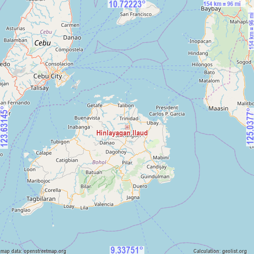
Hinlayagan Ilaud GPS coordinates[2]
10° 1' 50.196" North, 124° 20' 4.452" East
| Map corner | latitude | longitude |
|---|---|---|
| Upper-left | 10.72223°, | 123.63145° |
| Center: | 10.03061°, | 124.33457° |
| Lower-right: | 9.33751°, | 125.0377° |
| Map W x H: | 154×154 km | = 95.7×95.7mi |
| max Lat: | 20.78733° ⇑68% North |
| Hinlayagan Ilaud: | 10.03061° |
| min Lat: | ⇓32% South 4.65442° |
| min Long | Hinlayagan Ilau | max Long |
| 117.04868° | 124.33457° | 126.58417° |
| W 76.3%⇐ | ⇒23.7% E |
Elevation
Elevation of Hinlayagan Ilaud is 26 m = 85 ft, and this is 61.9 m = 203 ft below average elevation for this country.
| Max E: |
2262 m = 7421 ft | 46.5% |
| Avg. | 87.9 m = 288 ft | |
| Hinlayagan Ilaud | 26 m = 85 ft | |
Min E: |
-2 m = -7 ft | 53.5% |
See also: Philippines elevation on elevation.city.
Geographical zone
Hinlayagan Ilaud is located in North Torrid zone (between Equator and Tropic of Cancer). Distance of Equator is 1115.3 km =693 mi to South.| Distance of | km | miles | from Hinlayagan Ilaud |
|---|---|---|---|
| North Pole | 8891.8 | 5525.1 | to North |
| Arctic Circle | 6285.9 | 3905.9 | to North |
| Tropic Cancer | 1490.6 | 926.2 | to North |
| Equator | 1115.3 | 693 | to South |


Nearby cities:
15 places around Hinlayagan Ilaud: (largest is in red/bold)
• Bagacay
15.9 km =9.9 mi,  328°
328°
• Bien Unido
12.8 km =8 mi,  21°
21°
• Camambugan
11.8 km =7.3 mi,  74°
74°
• Dagohoy
15.6 km =9.7 mi,  201°
201°
• Danao
15.5 km =9.6 mi,  232°
232°
• Mahayag
10.8 km =6.7 mi,  190°
190°
• San Francisco
14.6 km =9.1 mi,  349°
349°
• San Miguel
4.9 km =3 mi,  171°
171°
• San Miguel
16.2 km =10.1 mi,  183°
183°
• San Pascual
13.4 km =8.3 mi,  129°
129°
• San Roque
6.9 km =4.3 mi, 349°
• Tagum Norte
7.7 km =4.8 mi,  50°
50°
• Talibon
13.2 km =8.2 mi,  355°
355°
• Trinidad
5.5 km =3.4 mi,  9°
9°
• Ubay
15.4 km =9.6 mi,  79°
79°
Sources, notices
• [Note1] Compared only with cities in Philippines existing in our database
• [Src1] Map data: © OpenStreetMap contributors (CC-BY-SA)
• [Src2] Other city data from geonames.org with taken over terms of usage.
• [Src3] Geographical zone / Annual Mean Temperature by Robert A. Rohde @ Wikipedia
