Tabuating geodata
Tabuating (Central Luzon) is a populated place; located in Philippines in Asia/Manila (GMT+8) time zone. With population of 4,120 people, there are 1656 cities with bigger population in this country. Compared to other cities in Philippines, 80.7% of cities are located further ↓South; 78% of cities are located further →East and 55.6% of cities have lower elevation than Tabuating. Note1
Administrative division(s):
- Level 1: Central Luzon
- Level 2: Province of Nueva Ecija
- Level 3: San Leonardo


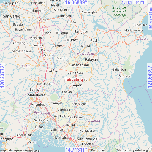
Tabuating GPS coordinates[2]
15° 23' 31.56" North, 120° 56' 27.024" East
| Map corner | latitude | longitude |
|---|---|---|
| Upper-left | 16.06889°, | 120.23772° |
| Center: | 15.3921°, | 120.94084° |
| Lower-right: | 14.71311°, | 121.64397° |
| Map W x H: | 150.7×150.8 km | = 93.6×93.7mi |
| max Lat: | 20.78733° ⇑19.3% North |
| Tabuating: | 15.3921° |
| min Lat: | ⇓80.7% South 4.65442° |
| min Long | Tabuating | max Long |
| 117.04868° | 120.94084° | 126.58417° |
| W 22%⇐ | ⇒78% E |
Elevation
Elevation of Tabuating is 28 m = 92 ft, and this is 59.9 m = 197 ft below average elevation for this country.
| Max E: |
2262 m = 7421 ft | 44.4% |
| Avg. | 87.9 m = 288 ft | |
| Tabuating | 28 m = 92 ft | |
Min E: |
-2 m = -7 ft | 55.6% |
See also: Philippines elevation on elevation.city.
Geographical zone
Tabuating is located in North Torrid zone (between Equator and Tropic of Cancer). Distance of this Northern Tropic circle is 894.5 km =555.8 mi to North.| Distance of | km | miles | from Tabuating |
|---|---|---|---|
| North Pole | 8295.6 | 5154.6 | to North |
| Arctic Circle | 5689.7 | 3535.4 | to North |
| Tropic Cancer | 894.5 | 555.8 | to North |
| Equator | 1711.4 | 1063.4 | to South |


Nearby cities:
15 places around Tabuating: (largest is in red/bold)
• Alua
10.3 km =6.4 mi,  209°
209°
• Gapan
9.5 km =5.9 mi,  176°
176°
• Jaen
7.5 km =4.7 mi,  197°
197°
• Lambakin
8.9 km =5.5 mi,  255°
255°
• Lawang Kupang
10.2 km =6.3 mi,  241°
241°
• Nieves
7.1 km =4.4 mi,  173°
173°
• Peñaranda
8.2 km =5.1 mi,  123°
123°
• Putlod
8.2 km =5.1 mi,  253°
253°
• Rajal Norte
10.2 km =6.3 mi,  304°
304°
• San Anton
5.4 km =3.4 mi, 204°
• San Leonardo
4.1 km =2.5 mi,  142°
142°
• San Mariano
10.5 km =6.5 mi,  221°
221°
• Santa Rosa
3.5 km =2.2 mi,  354°
354°
• Santo Rosario
7.2 km =4.5 mi,  310°
310°
• Soledad
6.1 km =3.8 mi,  48°
48°
Sources, notices
• [Note1] Compared only with cities in Philippines existing in our database
• [Src1] Map data: © OpenStreetMap contributors (CC-BY-SA)
• [Src2] Other city data from geonames.org with taken over terms of usage.
• [Src3] Geographical zone / Annual Mean Temperature by Robert A. Rohde @ Wikipedia
