Igcocolo geodata
Igcocolo (Western Visayas) is a populated place; located in Philippines in Asia/Manila (GMT+8) time zone. With population of 2,297 people, there are 3689 cities with bigger population in this country. Compared to other cities in Philippines, 61% of cities are located further ↑North; 57% of cities are located further →East and 58.1% of cities have lower elevation than Igcocolo. Note1


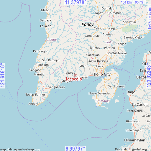
Igcocolo GPS coordinates[2]
10° 41' 22.776" North, 122° 19' 9.48" East
| Map corner | latitude | longitude |
|---|---|---|
| Upper-left | 11.37978°, | 121.61618° |
| Center: | 10.68966°, | 122.3193° |
| Lower-right: | 9.99797°, | 123.02243° |
| Map W x H: | 153.6×153.6 km | = 95.4×95.4mi |
| max Lat: | 20.78733° ⇑61% North |
| Igcocolo: | 10.68966° |
| min Lat: | ⇓39% South 4.65442° |
| min Long | Igcocolo | max Long |
| 117.04868° | 122.3193° | 126.58417° |
| W 43%⇐ | ⇒57% E |
Elevation
Elevation of Igcocolo is 31 m = 102 ft, and this is 56.9 m = 187 ft below average elevation for this country.
| Max E: |
2262 m = 7421 ft | 41.9% |
| Avg. | 87.9 m = 288 ft | |
| Igcocolo | 31 m = 102 ft | |
Min E: |
-2 m = -7 ft | 58.1% |
See also: Philippines elevation on elevation.city.
Geographical zone
Igcocolo is located in North Torrid zone (between Equator and Tropic of Cancer). Distance of Equator is 1188.6 km =738.6 mi to South.| Distance of | km | miles | from Igcocolo |
|---|---|---|---|
| North Pole | 8818.5 | 5479.6 | to North |
| Arctic Circle | 6212.6 | 3860.3 | to North |
| Tropic Cancer | 1417.3 | 880.7 | to North |
| Equator | 1188.6 | 738.6 | to South |


Nearby cities:
15 places around Igcocolo: (largest is in red/bold)
• Atabayan
10.7 km =6.6 mi,  93°
93°
• Buga
6.5 km =4 mi,  297°
297°
• Buray
15.6 km =9.7 mi,  79°
79°
• Buyuan
4.7 km =2.9 mi,  116°
116°
• Cordova
10 km =6.2 mi,  63°
63°
• Guimbal
3 km =1.9 mi,  172°
172°
• Igbaras
6.5 km =4 mi, 296°
• Leon
12.7 km =7.9 mi,  37°
37°
• Miagao
10.5 km =6.5 mi,  241°
241°
• Napnapan
8.3 km =5.2 mi, 75°
• Oton
16.9 km =10.5 mi, 88°
• Santa Monica
15.5 km =9.6 mi,  70°
70°
• Tigbauan
6.6 km =4.1 mi,  104°
104°
• Trapiche
12.4 km =7.7 mi, 92°
• Tubungan
8.3 km =5.2 mi,  358°
358°
Sources, notices
• [Note1] Compared only with cities in Philippines existing in our database
• [Src1] Map data: © OpenStreetMap contributors (CC-BY-SA)
• [Src2] Other city data from geonames.org with taken over terms of usage.
• [Src3] Geographical zone / Annual Mean Temperature by Robert A. Rohde @ Wikipedia
