Manggahan geodata
Manggahan (Calabarzon) is a populated place; located in Philippines in Asia/Manila (GMT+8) time zone. With population of 13,825 people, there are 474 cities with bigger population in this country. Compared to other cities in Philippines, 72.8% of cities are located further ↓South; 79.3% of cities are located further →East and 83.4% of cities have lower elevation than Manggahan. Note1
Administrative division(s):
- Level 1: Calabarzon
- Level 2: Province of Cavite
- Level 3: City of General Trias


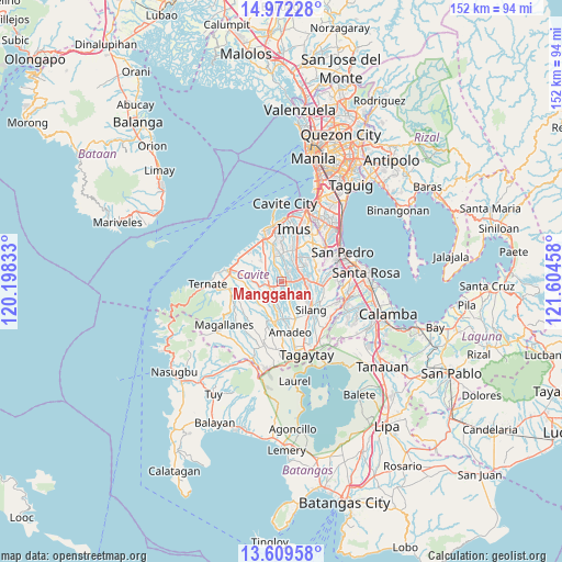
Manggahan GPS coordinates[2]
14° 17' 31.056" North, 120° 54' 5.22" East
| Map corner | latitude | longitude |
|---|---|---|
| Upper-left | 14.97228°, | 120.19833° |
| Center: | 14.29196°, | 120.90145° |
| Lower-right: | 13.60958°, | 121.60458° |
| Map W x H: | 151.5×151.5 km | = 94.1×94.1mi |
| max Lat: | 20.78733° ⇑27.2% North |
| Manggahan: | 14.29196° |
| min Lat: | ⇓72.8% South 4.65442° |
| min Long | Manggahan | max Long |
| 117.04868° | 120.90145° | 126.58417° |
| W 20.7%⇐ | ⇒79.3% E |
Elevation
Elevation of Manggahan is 119 m = 390 ft, and this is 31.1 m = 102 ft above average elevation for this country.
| Max E: |
2262 m = 7421 ft | 16.6% |
| Manggahan | 119 m 390 ft | |
| Avg. | 87.9 m = 288 ft | |
Min E: |
-2 m = -7 ft | 83.4% |
See also: Philippines elevation on elevation.city.
Geographical zone
Manggahan is located in North Torrid zone (between Equator and Tropic of Cancer). Distance of this Northern Tropic circle is 1016.8 km =631.8 mi to North.| Distance of | km | miles | from Manggahan |
|---|---|---|---|
| North Pole | 8417.9 | 5230.6 | to North |
| Arctic Circle | 5812.1 | 3611.5 | to North |
| Tropic Cancer | 1016.8 | 631.8 | to North |
| Equator | 1589.1 | 987.4 | to South |


Nearby cities:
15 places around Manggahan: (largest is in red/bold)
• Aliang
2.2 km =1.4 mi,  243°
243°
• Banaba
10 km =6.2 mi,  213°
213°
• Biga
8.5 km =5.3 mi,  116°
116°
• Bitangan
4.9 km =3 mi, 210°
• Bulihan
10.2 km =6.3 mi,  98°
98°
• Dasmariñas
5.6 km =3.5 mi,  42°
42°
• General Trias
10.8 km =6.7 mi,  348°
348°
• Indang
11.1 km =6.9 mi,  193°
193°
• Javalera
4.1 km =2.5 mi,  157°
157°
• Palangue
9.7 km =6 mi,  264°
264°
• Pangil
10.1 km =6.3 mi,  176°
176°
• Paradahan
5.5 km =3.4 mi,  306°
306°
• Pasong Kawayan Primero
6.1 km =3.8 mi,  339°
339°
• Sabang
10.6 km =6.6 mi,  278°
278°
• Silang
11.3 km =7 mi,  138°
138°
Sources, notices
• [Note1] Compared only with cities in Philippines existing in our database
• [Src1] Map data: © OpenStreetMap contributors (CC-BY-SA)
• [Src2] Other city data from geonames.org with taken over terms of usage.
• [Src3] Geographical zone / Annual Mean Temperature by Robert A. Rohde @ Wikipedia
