Aliang geodata
Aliang (Calabarzon) is a populated place; located in Philippines in Asia/Manila (GMT+8) time zone. With population of 2,642 people, there are 3042 cities with bigger population in this country. Compared to other cities in Philippines, 72.7% of cities are located further ↓South; 79.9% of cities are located further →East and 83.9% of cities have lower elevation than Aliang. Note1
Administrative division(s):
- Level 1: Calabarzon
- Level 2: Province of Cavite
- Level 3: Trece Martires City


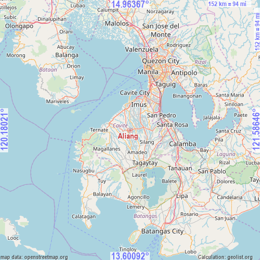
Aliang GPS coordinates[2]
14° 16' 59.988" North, 120° 52' 59.988" East
| Map corner | latitude | longitude |
|---|---|---|
| Upper-left | 14.96367°, | 120.18021° |
| Center: | 14.28333°, | 120.88333° |
| Lower-right: | 13.60092°, | 121.58646° |
| Map W x H: | 151.5×151.5 km | = 94.1×94.1mi |
| max Lat: | 20.78733° ⇑27.3% North |
| Aliang: | 14.28333° |
| min Lat: | ⇓72.7% South 4.65442° |
| min Long | Aliang | max Long |
| 117.04868° | 120.88333° | 126.58417° |
| W 20.1%⇐ | ⇒79.9% E |
Elevation
Elevation of Aliang is 124 m = 407 ft, and this is 36.1 m = 118 ft above average elevation for this country.
| Max E: |
2262 m = 7421 ft | 16.1% |
| Aliang | 124 m 407 ft | |
| Avg. | 87.9 m = 288 ft | |
Min E: |
-2 m = -7 ft | 83.9% |
See also: Philippines elevation on elevation.city.
Geographical zone
Aliang is located in North Torrid zone (between Equator and Tropic of Cancer). Distance of this Northern Tropic circle is 1017.8 km =632.4 mi to North.| Distance of | km | miles | from Aliang |
|---|---|---|---|
| North Pole | 8418.9 | 5231.3 | to North |
| Arctic Circle | 5813 | 3612 | to North |
| Tropic Cancer | 1017.8 | 632.4 | to North |
| Equator | 1588.2 | 986.9 | to South |


Nearby cities:
15 places around Aliang: (largest is in red/bold)
• Banaba
8.2 km =5.1 mi,  205°
205°
• Biga
10 km =6.2 mi,  106°
106°
• Bitangan
3.3 km =2.1 mi,  189°
189°
• Dasmariñas
7.7 km =4.8 mi,  48°
48°
• General Trias
11.5 km =7.1 mi,  359°
359°
• Indang
9.8 km =6.1 mi,  184°
184°
• Javalera
4.5 km =2.8 mi,  128°
128°
• Malainen Luma
10.3 km =6.4 mi,  261°
261°
• Manggahan
2.2 km =1.4 mi,  63°
63°
• Palangue
7.8 km =4.8 mi,  270°
270°
• Pangil
9.5 km =5.9 mi,  163°
163°
• Pantijan No 2
10.5 km =6.5 mi,  237°
237°
• Paradahan
4.9 km =3 mi,  329°
329°
• Pasong Kawayan Primero
6.7 km =4.2 mi, 358°
• Sabang
8.9 km =5.5 mi,  286°
286°
Sources, notices
• [Note1] Compared only with cities in Philippines existing in our database
• [Src1] Map data: © OpenStreetMap contributors (CC-BY-SA)
• [Src2] Other city data from geonames.org with taken over terms of usage.
• [Src3] Geographical zone / Annual Mean Temperature by Robert A. Rohde @ Wikipedia
