Rizal geodata
Rizal (Central Luzon) is a seat of a third-order administrative division; located in Philippines in Asia/Manila (GMT+8) time zone. With population of 26,201 people, there are 312 cities with bigger population in this country. Compared to other cities in Philippines, 84% of cities are located further ↓South; 73.7% of cities are located further →East and 79.9% of cities have lower elevation than Rizal. Note1


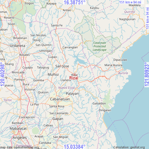
Rizal GPS coordinates[2]
15° 42' 42.48" North, 121° 6' 21.96" East
| Map corner | latitude | longitude |
|---|---|---|
| Upper-left | 16.38751°, | 120.40298° |
| Center: | 15.7118°, | 121.1061° |
| Lower-right: | 15.03384°, | 121.80923° |
| Map W x H: | 150.5×150.5 km | = 93.5×93.5mi |
| max Lat: | 20.78733° ⇑16% North |
| Rizal: | 15.7118° |
| min Lat: | ⇓84% South 4.65442° |
| min Long | Rizal | max Long |
| 117.04868° | 121.1061° | 126.58417° |
| W 26.3%⇐ | ⇒73.7% E |
Elevation
Elevation of Rizal is 91 m = 299 ft, and this is 3.1 m = 10 ft above average elevation for this country.
| Max E: |
2262 m = 7421 ft | 20.1% |
| Rizal | 91 m 299 ft | |
| Avg. | 87.9 m = 288 ft | |
Min E: |
-2 m = -7 ft | 79.9% |
See also: Philippines elevation on elevation.city.
Geographical zone
Rizal is located in North Torrid zone (between Equator and Tropic of Cancer). Distance of this Northern Tropic circle is 858.9 km =533.7 mi to North.| Distance of | km | miles | from Rizal |
|---|---|---|---|
| North Pole | 8260.1 | 5132.6 | to North |
| Arctic Circle | 5654.2 | 3513.4 | to North |
| Tropic Cancer | 858.9 | 533.7 | to North |
| Equator | 1747 | 1085.5 | to South |


Nearby cities:
15 places around Rizal: (largest is in red/bold)
• Agbannawag
4.4 km =2.7 mi,  213°
213°
• Bicos
9 km =5.6 mi,  230°
230°
• Bongabon
9.8 km =6.1 mi,  154°
154°
• Del Pilar
2.8 km =1.7 mi, 229°
• Estrella
8.9 km =5.5 mi,  298°
298°
• General Luna
8.1 km =5 mi,  75°
75°
• General Mamerto Natividad
13.5 km =8.4 mi, 205°
• Llanera
10.8 km =6.7 mi,  240°
240°
• Macapsing
4.6 km =2.9 mi,  143°
143°
• Paco Roman
6.1 km =3.8 mi,  198°
198°
• Pantabangan
11.8 km =7.3 mi,  20°
20°
• Piñahan
10.6 km =6.6 mi, 206°
• Plaridel
10.9 km =6.8 mi, 237°
• Porais
8.3 km =5.2 mi,  305°
305°
• Sapang Buho
13.6 km =8.5 mi,  171°
171°
Sources, notices
• [Note1] Compared only with cities in Philippines existing in our database
• [Src1] Map data: © OpenStreetMap contributors (CC-BY-SA)
• [Src2] Other city data from geonames.org with taken over terms of usage.
• [Src3] Geographical zone / Annual Mean Temperature by Robert A. Rohde @ Wikipedia
