Agbannawag geodata
Agbannawag (Central Luzon) is a populated place; located in Philippines in Asia/Manila (GMT+8) time zone. With population of 3,782 people, there are 1859 cities with bigger population in this country. Compared to other cities in Philippines, 83.7% of cities are located further ↓South; 74.3% of cities are located further →East and 78.7% of cities have lower elevation than Agbannawag. Note1


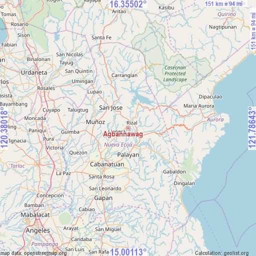
Agbannawag GPS coordinates[2]
15° 40' 45.12" North, 121° 4' 59.88" East
| Map corner | latitude | longitude |
|---|---|---|
| Upper-left | 16.35502°, | 120.38018° |
| Center: | 15.6792°, | 121.0833° |
| Lower-right: | 15.00113°, | 121.78643° |
| Map W x H: | 150.5×150.5 km | = 93.5×93.5mi |
| max Lat: | 20.78733° ⇑16.3% North |
| Agbannawag: | 15.6792° |
| min Lat: | ⇓83.7% South 4.65442° |
| min Long | Agbannawag | max Long |
| 117.04868° | 121.0833° | 126.58417° |
| W 25.7%⇐ | ⇒74.3% E |
Elevation
Elevation of Agbannawag is 84 m = 276 ft, and this is 3.9 m = 13 ft below average elevation for this country.
| Max E: |
2262 m = 7421 ft | 21.3% |
| Avg. | 87.9 m = 288 ft | |
| Agbannawag | 84 m = 276 ft | |
Min E: |
-2 m = -7 ft | 78.7% |
See also: Philippines elevation on elevation.city.
Geographical zone
Agbannawag is located in North Torrid zone (between Equator and Tropic of Cancer). Distance of this Northern Tropic circle is 862.6 km =536 mi to North.| Distance of | km | miles | from Agbannawag |
|---|---|---|---|
| North Pole | 8263.7 | 5134.8 | to North |
| Arctic Circle | 5657.8 | 3515.6 | to North |
| Tropic Cancer | 862.6 | 536 | to North |
| Equator | 1743.4 | 1083.3 | to South |


Nearby cities:
15 places around Agbannawag: (largest is in red/bold)
• Bicos
5 km =3.1 mi,  244°
244°
• Bongabon
8.4 km =5.2 mi,  128°
128°
• Del Pilar
1.9 km =1.2 mi,  9°
9°
• Estrella
9.5 km =5.9 mi,  325°
325°
• General Luna
11.7 km =7.3 mi,  60°
60°
• General Mamerto Natividad
9.2 km =5.7 mi,  201°
201°
• Llanera
7.2 km =4.5 mi,  255°
255°
• Macapsing
5.2 km =3.2 mi,  91°
91°
• Paco Roman
2.2 km =1.4 mi,  167°
167°
• Piñahan
6.3 km =3.9 mi, 201°
• Plaridel
7.1 km =4.4 mi,  251°
251°
• Porais
9.5 km =5.9 mi, 332°
• Rizal
4.4 km =2.7 mi,  33°
33°
• Sapang Buho
10.8 km =6.7 mi,  155°
155°
• Tondod
13.1 km =8.1 mi,  289°
289°
Sources, notices
• [Note1] Compared only with cities in Philippines existing in our database
• [Src1] Map data: © OpenStreetMap contributors (CC-BY-SA)
• [Src2] Other city data from geonames.org with taken over terms of usage.
• [Src3] Geographical zone / Annual Mean Temperature by Robert A. Rohde @ Wikipedia
