San Miguel geodata
San Miguel (Mimaropa) is a populated place; located in Philippines in Asia/Manila (GMT+8) time zone. With population of 2,972 people, there are 2564 cities with bigger population in this country. Compared to other cities in Philippines, 51.4% of cities are located further ↑North; 98.1% of cities are located further →East and 60.8% of cities have higher elevation than San Miguel. Note1


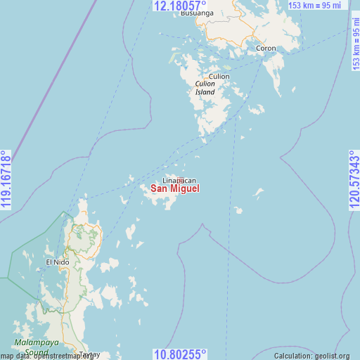
San Miguel GPS coordinates[2]
11° 29' 32.64" North, 119° 52' 13.08" East
| Map corner | latitude | longitude |
|---|---|---|
| Upper-left | 12.18057°, | 119.16718° |
| Center: | 11.4924°, | 119.8703° |
| Lower-right: | 10.80255°, | 120.57343° |
| Map W x H: | 153.2×153.2 km | = 95.2×95.2mi |
| max Lat: | 20.78733° ⇑51.4% North |
| San Miguel: | 11.4924° |
| min Lat: | ⇓48.6% South 4.65442° |
| min Long | San Miguel | max Long |
| 117.04868° | 119.8703° | 126.58417° |
| W 1.9%⇐ | ⇒98.1% E |
Elevation
Elevation of San Miguel is 16 m = 52 ft, and this is 71.9 m = 236 ft below average elevation for this country.
| Max E: |
2262 m = 7421 ft | 60.8% |
| Avg. | 87.9 m = 288 ft | |
| San Miguel | 16 m = 52 ft | |
Min E: |
-2 m = -7 ft | 39.2% |
See also: Philippines elevation on elevation.city.
Geographical zone
San Miguel is located in North Torrid zone (between Equator and Tropic of Cancer). Distance of Equator is 1277.8 km =794 mi to South.| Distance of | km | miles | from San Miguel |
|---|---|---|---|
| North Pole | 8729.2 | 5424.1 | to North |
| Arctic Circle | 6123.3 | 3804.8 | to North |
| Tropic Cancer | 1328.1 | 825.2 | to North |
| Equator | 1277.8 | 794 | to South |


Nearby cities:
15 places around San Miguel: (largest is in red/bold)
• Bato
86 km =53.4 mi,  210°
210°
• Bulalacao
43.1 km =26.8 mi,  49°
49°
• Buluang
82.4 km =51.2 mi,  0°
0°
• Busuanga
74.2 km =46.1 mi, 3°
• Calauag
97.3 km =60.5 mi,  199°
199°
• Casian
53.7 km =33.4 mi, 198°
• Coron
67 km =41.6 mi,  32°
32°
• El Nido
62 km =38.5 mi,  236°
236°
• Guinlo
90.2 km =56 mi, 211°
• Limanancong
79 km =49.1 mi,  224°
224°
• Pancol
85 km =52.8 mi, 215°
• Panlaitan
69.7 km =43.3 mi,  358°
358°
• Salvacion
71.5 km =44.4 mi,  5°
5°
• Taytay
85.3 km =53 mi, 208°
• Tiniguiban
42.6 km =26.5 mi,  249°
249°
Sources, notices
• [Note1] Compared only with cities in Philippines existing in our database
• [Src1] Map data: © OpenStreetMap contributors (CC-BY-SA)
• [Src2] Other city data from geonames.org with taken over terms of usage.
• [Src3] Geographical zone / Annual Mean Temperature by Robert A. Rohde @ Wikipedia
