Dolores geodata
Dolores (Eastern Visayas) is a populated place; located in Philippines in Asia/Manila (GMT+8) time zone. With population of 9,274 people, there are 663 cities with bigger population in this country. Compared to other cities in Philippines, 51.9% of cities are located further ↓South; 93.3% of cities are located further ←West and 89.7% of cities have higher elevation than Dolores. Note1
Administrative division(s):
- Level 1: Eastern Visayas
- Level 2: Province of Eastern Samar
- Level 3: Dolores


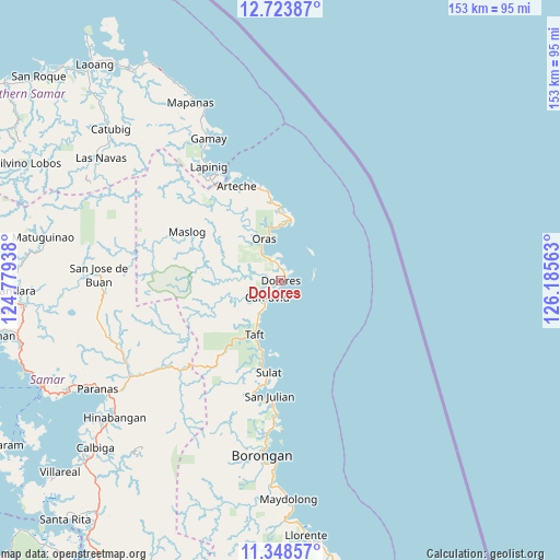
Dolores GPS coordinates[2]
12° 2' 13.56" North, 125° 28' 57" East
| Map corner | latitude | longitude |
|---|---|---|
| Upper-left | 12.72387°, | 124.77938° |
| Center: | 12.0371°, | 125.4825° |
| Lower-right: | 11.34857°, | 126.18563° |
| Map W x H: | 152.9×152.9 km | = 95×95mi |
| max Lat: | 20.78733° ⇑48.1% North |
| Dolores: | 12.0371° |
| min Lat: | ⇓51.9% South 4.65442° |
| min Long | Dolores | max Long |
| 117.04868° | 125.4825° | 126.58417° |
| W 93.3%⇐ | ⇒6.7% E |
Elevation
Elevation of Dolores is 7 m = 23 ft, and this is 80.9 m = 265 ft below average elevation for this country.
| Max E: |
2262 m = 7421 ft | 89.7% |
| Avg. | 87.9 m = 288 ft | |
| Dolores | 7 m = 23 ft | |
Min E: |
-2 m = -7 ft | 10.3% |
See also: Philippines elevation on elevation.city.
Geographical zone
Dolores is located in North Torrid zone (between Equator and Tropic of Cancer). Distance of this Northern Tropic circle is 1267.5 km =787.6 mi to North.| Distance of | km | miles | from Dolores |
|---|---|---|---|
| North Pole | 8668.7 | 5386.5 | to North |
| Arctic Circle | 6062.8 | 3767.2 | to North |
| Tropic Cancer | 1267.5 | 787.6 | to North |
| Equator | 1338.4 | 831.6 | to South |


Nearby cities:
15 places around Dolores: (largest is in red/bold)
• Alugan
20.2 km =12.6 mi,  359°
359°
• Arteche
26.7 km =16.6 mi,  341°
341°
• Can-Avid
6 km =3.7 mi,  219°
219°
• Dao
8.5 km =5.3 mi,  324°
324°
• Dapdap
2.8 km =1.7 mi,  12°
12°
• Lapinig
36.5 km =22.7 mi,  327°
327°
• Mantang
19.5 km =12.1 mi,  197°
197°
• Maslog
29.9 km =18.6 mi,  294°
294°
• Nena
31 km =19.3 mi,  193°
193°
• Oras
12.4 km =7.7 mi, 337°
• San Eduardo
15 km =9.3 mi,  346°
346°
• San Julian
31.7 km =19.7 mi, 185°
• San Policarpo
16 km =9.9 mi, 9°
• Sulat
25.4 km =15.8 mi, 186°
• Taft
16.6 km =10.3 mi, 204°
Sources, notices
• [Note1] Compared only with cities in Philippines existing in our database
• [Src1] Map data: © OpenStreetMap contributors (CC-BY-SA)
• [Src2] Other city data from geonames.org with taken over terms of usage.
• [Src3] Geographical zone / Annual Mean Temperature by Robert A. Rohde @ Wikipedia
