Taft geodata
Taft (Eastern Visayas) is a seat of a third-order administrative division; located in Philippines in Asia/Manila (GMT+8) time zone. With population of 4,421 people, there are 1530 cities with bigger population in this country. Compared to other cities in Philippines, 51.4% of cities are located further ↓South; 92.3% of cities are located further ←West and 80.7% of cities have higher elevation than Taft. Note1
Administrative division(s):
- Level 1: Eastern Visayas
- Level 2: Province of Eastern Samar
- Level 3: Taft


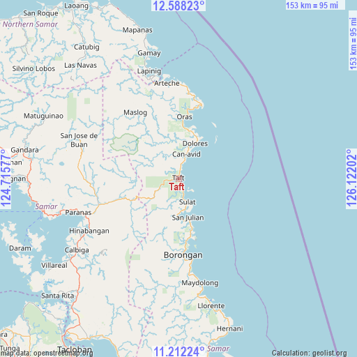
Taft GPS coordinates[2]
11° 54' 3.996" North, 125° 25' 8.004" East
| Map corner | latitude | longitude |
|---|---|---|
| Upper-left | 12.58823°, | 124.71577° |
| Center: | 11.90111°, | 125.41889° |
| Lower-right: | 11.21224°, | 126.12202° |
| Map W x H: | 153×153 km | = 95.1×95.1mi |
| max Lat: | 20.78733° ⇑48.6% North |
| Taft: | 11.90111° |
| min Lat: | ⇓51.4% South 4.65442° |
| min Long | Taft | max Long |
| 117.04868° | 125.41889° | 126.58417° |
| W 92.3%⇐ | ⇒7.7% E |
Elevation
Elevation of Taft is 9 m = 30 ft, and this is 78.9 m = 259 ft below average elevation for this country.
| Max E: |
2262 m = 7421 ft | 80.7% |
| Avg. | 87.9 m = 288 ft | |
| Taft | 9 m = 30 ft | |
Min E: |
-2 m = -7 ft | 19.3% |
See also: Philippines elevation on elevation.city.
Geographical zone
Taft is located in North Torrid zone (between Equator and Tropic of Cancer). Distance of this Northern Tropic circle is 1282.6 km =797 mi to North.| Distance of | km | miles | from Taft |
|---|---|---|---|
| North Pole | 8683.8 | 5395.9 | to North |
| Arctic Circle | 6077.9 | 3776.6 | to North |
| Tropic Cancer | 1282.6 | 797 | to North |
| Equator | 1323.3 | 822.3 | to South |


Nearby cities:
15 places around Taft: (largest is in red/bold)
• Balud
31.7 km =19.7 mi,  177°
177°
• Borongan
32.6 km =20.3 mi, 177°
• Can-Avid
10.9 km =6.8 mi,  16°
16°
• Dao
22.2 km =13.8 mi,  5°
5°
• Dapdap
19.4 km =12.1 mi, 22°
• Dolores
16.6 km =10.3 mi, 24°
• Mantang
3.6 km =2.2 mi,  163°
163°
• Maypangdan
27.9 km =17.3 mi,  172°
172°
• Nena
15 km =9.3 mi, 180°
• Oras
26.7 km =16.6 mi,  4°
4°
• Paranas
33.5 km =20.8 mi,  260°
260°
• San Eduardo
29.9 km =18.6 mi, 6°
• San Julian
16.9 km =10.5 mi, 166°
• San Policarpo
32.4 km =20.1 mi, 17°
• Sulat
10.8 km =6.7 mi, 159°
Sources, notices
• [Note1] Compared only with cities in Philippines existing in our database
• [Src1] Map data: © OpenStreetMap contributors (CC-BY-SA)
• [Src2] Other city data from geonames.org with taken over terms of usage.
• [Src3] Geographical zone / Annual Mean Temperature by Robert A. Rohde @ Wikipedia
