Dingalan geodata
Dingalan (Central Luzon) is a populated place; located in Philippines in Asia/Manila (GMT+8) time zone. With population of 7,315 people, there are 852 cities with bigger population in this country. Compared to other cities in Philippines, 80.7% of cities are located further ↓South; 68.7% of cities are located further →East and 60.3% of cities have lower elevation than Dingalan. Note1


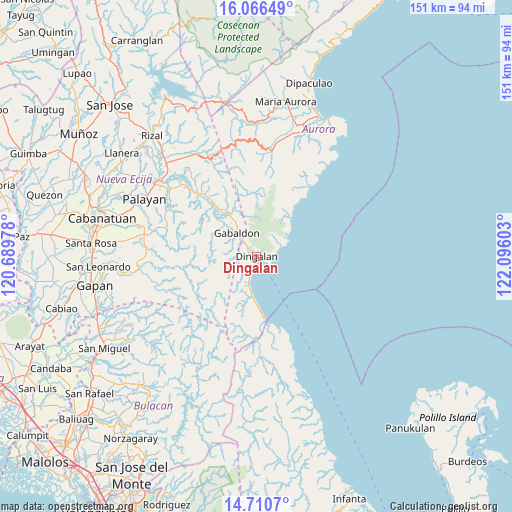
Dingalan GPS coordinates[2]
15° 23' 22.92" North, 121° 23' 34.44" East
| Map corner | latitude | longitude |
|---|---|---|
| Upper-left | 16.06649°, | 120.68978° |
| Center: | 15.3897°, | 121.3929° |
| Lower-right: | 14.7107°, | 122.09603° |
| Map W x H: | 150.7×150.8 km | = 93.6×93.7mi |
| max Lat: | 20.78733° ⇑19.3% North |
| Dingalan: | 15.3897° |
| min Lat: | ⇓80.7% South 4.65442° |
| min Long | Dingalan | max Long |
| 117.04868° | 121.3929° | 126.58417° |
| W 31.3%⇐ | ⇒68.7% E |
Elevation
Elevation of Dingalan is 34 m = 112 ft, and this is 53.9 m = 177 ft below average elevation for this country.
| Max E: |
2262 m = 7421 ft | 39.7% |
| Avg. | 87.9 m = 288 ft | |
| Dingalan | 34 m = 112 ft | |
Min E: |
-2 m = -7 ft | 60.3% |
See also: Philippines elevation on elevation.city.
Geographical zone
Dingalan is located in North Torrid zone (between Equator and Tropic of Cancer). Distance of this Northern Tropic circle is 894.7 km =555.9 mi to North.| Distance of | km | miles | from Dingalan |
|---|---|---|---|
| North Pole | 8295.9 | 5154.8 | to North |
| Arctic Circle | 5690 | 3535.6 | to North |
| Tropic Cancer | 894.7 | 555.9 | to North |
| Equator | 1711.2 | 1063.3 | to South |


Nearby cities:
15 places around Dingalan: (largest is in red/bold)
• Antipolo
33.4 km =20.8 mi,  319°
319°
• Bagong-Sikat
13.6 km =8.5 mi, 317°
• Cabog
8.6 km =5.3 mi,  196°
196°
• Gabaldon
9.1 km =5.7 mi, 320°
• General Tinio
37.3 km =23.2 mi,  263°
263°
• Laur
31.3 km =19.4 mi,  314°
314°
• Ligaya
17.5 km =10.9 mi, 319°
• Macatbong
36 km =22.4 mi,  290°
290°
• Mapalad
33.8 km =21 mi,  281°
281°
• Palayan City
37.1 km =23.1 mi,  297°
297°
• Pias
34.5 km =21.4 mi, 261°
• Sagana
32.6 km =20.3 mi, 307°
• Sapang Buho
36.4 km =22.6 mi, 307°
• Siclong
27.9 km =17.3 mi, 319°
• Umiray
18.9 km =11.7 mi,  174°
174°
Sources, notices
• [Note1] Compared only with cities in Philippines existing in our database
• [Src1] Map data: © OpenStreetMap contributors (CC-BY-SA)
• [Src2] Other city data from geonames.org with taken over terms of usage.
• [Src3] Geographical zone / Annual Mean Temperature by Robert A. Rohde @ Wikipedia
