Pias geodata
Pias (Central Luzon) is a populated place; located in Philippines in Asia/Manila (GMT+8) time zone. With population of 3,788 people, there are 1852 cities with bigger population in this country. Compared to other cities in Philippines, 80.3% of cities are located further ↓South; 74.5% of cities are located further →East and 70.8% of cities have lower elevation than Pias. Note1
Administrative division(s):
- Level 1: Central Luzon
- Level 2: Province of Nueva Ecija
- Level 3: General Tinio (Papaya)


Pias GPS coordinates[2]
15° 20' 42.9" North, 121° 4' 29.028" East
| Map corner | latitude | longitude |
|---|---|---|
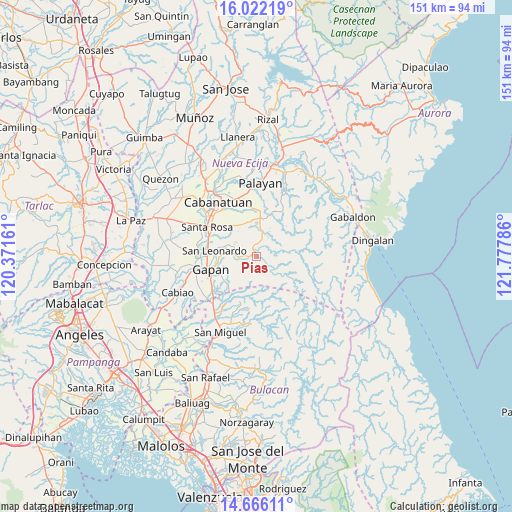
| Upper-left | 16.02219°, | 120.37161° |
| Center: | 15.34525°, | 121.07473° |
| Lower-right: | 14.66611°, | 121.77786° |
| Map W x H: | 150.8×150.8 km | = 93.7×93.7mi |
| max Lat: | 20.78733° ⇑19.7% North |
| Pias: | 15.34525° |
| min Lat: | ⇓80.3% South 4.65442° |
| min Long | Pias | max Long |
| 117.04868° | 121.07473° | 126.58417° |
| W 25.5%⇐ | ⇒74.5% E |
Elevation
Elevation of Pias is 54 m = 177 ft, and this is 33.9 m = 111 ft below average elevation for this country.
| Max E: |
2262 m = 7421 ft | 29.2% |
| Avg. | 87.9 m = 288 ft | |
| Pias | 54 m = 177 ft | |
Min E: |
-2 m = -7 ft | 70.8% |
See also: Philippines elevation on elevation.city.
Geographical zone
Pias is located in North Torrid zone (between Equator and Tropic of Cancer). Distance of this Northern Tropic circle is 899.7 km =559 mi to North.| Distance of | km | miles | from Pias |
|---|---|---|---|
| North Pole | 8300.8 | 5157.9 | to North |
| Arctic Circle | 5694.9 | 3538.6 | to North |
| Tropic Cancer | 899.7 | 559 | to North |
| Equator | 1706.2 | 1060.2 | to South |


Nearby cities:
15 places around Pias: (largest is in red/bold)
• Bangad
18.1 km =11.2 mi,  343°
343°
• Gapan
14.4 km =8.9 mi,  252°
252°
• General Tinio
3 km =1.9 mi,  281°
281°
• Jaen
16.8 km =10.4 mi,  263°
263°
• Macatbong
17.7 km =11 mi,  1°
1°
• Mapalad
11.8 km =7.3 mi, 4°
• Nieves
13.6 km =8.5 mi, 262°
• Peñaranda
7.6 km =4.7 mi,  274°
274°
• Pinambaran
19 km =11.8 mi,  213°
213°
• San Anton
16.6 km =10.3 mi, 270°
• San Leonardo
12 km =7.5 mi, 279°
• Santa Lucia
16.8 km =10.4 mi, 206°
• Santa Rosa
17.1 km =10.6 mi,  300°
300°
• Soledad
13.5 km =8.4 mi,  313°
313°
• Tabuating
15.3 km =9.5 mi,  289°
289°
Sources, notices
• [Note1] Compared only with cities in Philippines existing in our database
• [Src1] Map data: © OpenStreetMap contributors (CC-BY-SA)
• [Src2] Other city data from geonames.org with taken over terms of usage.
• [Src3] Geographical zone / Annual Mean Temperature by Robert A. Rohde @ Wikipedia
