Antipolo geodata
Antipolo (Central Luzon) is a populated place; located in Philippines in Asia/Manila (GMT+8) time zone. With population of 3,486 people, there are 2063 cities with bigger population in this country. Compared to other cities in Philippines, 82.9% of cities are located further ↓South; 71.8% of cities are located further →East and 79.2% of cities have lower elevation than Antipolo. Note1
Administrative division(s):
- Level 1: Central Luzon
- Level 2: Province of Nueva Ecija
- Level 3: Bongabon


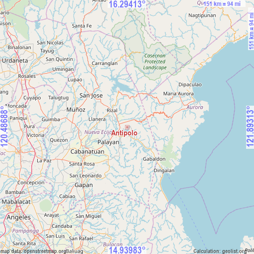
Antipolo GPS coordinates[2]
15° 37' 5.16" North, 121° 11' 24" East
| Map corner | latitude | longitude |
|---|---|---|
| Upper-left | 16.29413°, | 120.48688° |
| Center: | 15.6181°, | 121.19° |
| Lower-right: | 14.93983°, | 121.89313° |
| Map W x H: | 150.6×150.6 km | = 93.6×93.6mi |
| max Lat: | 20.78733° ⇑17.1% North |
| Antipolo: | 15.6181° |
| min Lat: | ⇓82.9% South 4.65442° |
| min Long | Antipolo | max Long |
| 117.04868° | 121.19° | 126.58417° |
| W 28.2%⇐ | ⇒71.8% E |
Elevation
Elevation of Antipolo is 87 m = 285 ft, and this is 0.90000000000001 m = 3 ft below average elevation for this country.
| Max E: |
2262 m = 7421 ft | 20.8% |
| Avg. | 87.9 m = 288 ft | |
| Antipolo | 87 m = 285 ft | |
Min E: |
-2 m = -7 ft | 79.2% |
See also: Philippines elevation on elevation.city.
Geographical zone
Antipolo is located in North Torrid zone (between Equator and Tropic of Cancer). Distance of this Northern Tropic circle is 869.3 km =540.2 mi to North.| Distance of | km | miles | from Antipolo |
|---|---|---|---|
| North Pole | 8270.5 | 5139 | to North |
| Arctic Circle | 5664.6 | 3519.8 | to North |
| Tropic Cancer | 869.3 | 540.2 | to North |
| Equator | 1736.6 | 1079.1 | to South |


Nearby cities:
15 places around Antipolo: (largest is in red/bold)
• Agbannawag
13.3 km =8.3 mi,  300°
300°
• Bongabon
5.1 km =3.2 mi,  287°
287°
• Del Pilar
14.1 km =8.8 mi,  307°
307°
• General Luna
12.6 km =7.8 mi,  354°
354°
• General Mamerto Natividad
14.9 km =9.3 mi,  263°
263°
• Laur
3.6 km =2.2 mi,  191°
191°
• Ligaya
16 km =9.9 mi,  139°
139°
• Macapsing
9.1 km =5.7 mi,  317°
317°
• Paco Roman
11.9 km =7.4 mi, 292°
• Palayan City
14.1 km =8.8 mi,  232°
232°
• Piñahan
13.7 km =8.5 mi,  273°
273°
• Rizal
13.8 km =8.6 mi, 319°
• Sagana
6.8 km =4.2 mi,  216°
216°
• Sapang Buho
7.7 km =4.8 mi,  246°
246°
• Siclong
5.5 km =3.4 mi, 138°
Sources, notices
• [Note1] Compared only with cities in Philippines existing in our database
• [Src1] Map data: © OpenStreetMap contributors (CC-BY-SA)
• [Src2] Other city data from geonames.org with taken over terms of usage.
• [Src3] Geographical zone / Annual Mean Temperature by Robert A. Rohde @ Wikipedia
