Cabog geodata
Cabog (Central Luzon) is a populated place; located in Philippines in Asia/Manila (GMT+8) time zone. With population of 2,967 people, there are 2569 cities with bigger population in this country. Compared to other cities in Philippines, 80% of cities are located further ↓South; 69.1% of cities are located further →East and 65.1% of cities have higher elevation than Cabog. Note1


Cabog GPS coordinates[2]
15° 18' 55.08" North, 121° 22' 13.08" East
| Map corner | latitude | longitude |
|---|---|---|
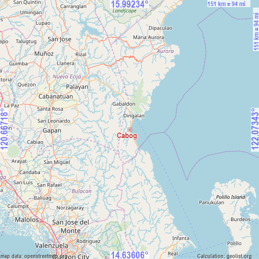
| Upper-left | 15.99234°, | 120.66718° |
| Center: | 15.3153°, | 121.3703° |
| Lower-right: | 14.63606°, | 122.07343° |
| Map W x H: | 150.8×150.8 km | = 93.7×93.7mi |
| max Lat: | 20.78733° ⇑20% North |
| Cabog: | 15.3153° |
| min Lat: | ⇓80% South 4.65442° |
| min Long | Cabog | max Long |
| 117.04868° | 121.3703° | 126.58417° |
| W 30.9%⇐ | ⇒69.1% E |
Elevation
Elevation of Cabog is 14 m = 46 ft, and this is 73.9 m = 242 ft below average elevation for this country.
| Max E: |
2262 m = 7421 ft | 65.1% |
| Avg. | 87.9 m = 288 ft | |
| Cabog | 14 m = 46 ft | |
Min E: |
-2 m = -7 ft | 34.9% |
See also: Philippines elevation on elevation.city.
Geographical zone
Cabog is located in North Torrid zone (between Equator and Tropic of Cancer). Distance of this Northern Tropic circle is 903 km =561.1 mi to North.| Distance of | km | miles | from Cabog |
|---|---|---|---|
| North Pole | 8304.2 | 5160 | to North |
| Arctic Circle | 5698.3 | 3540.8 | to North |
| Tropic Cancer | 903 | 561.1 | to North |
| Equator | 1702.9 | 1058.1 | to South |


Nearby cities:
15 places around Cabog: (largest is in red/bold)
• Antipolo
38.8 km =24.1 mi,  330°
330°
• Bagong-Sikat
19.5 km =12.1 mi,  339°
339°
• Dingalan
8.6 km =5.3 mi,  16°
16°
• Gabaldon
15.6 km =9.7 mi,  347°
347°
• General Tinio
34.8 km =21.6 mi,  276°
276°
• Laur
36.2 km =22.5 mi, 326°
• Ligaya
23.3 km =14.5 mi, 337°
• Macatbong
37.7 km =23.4 mi,  304°
304°
• Mapalad
34.2 km =21.3 mi, 296°
• Peñaranda
39.5 km =24.5 mi, 275°
• Pias
31.9 km =19.8 mi, 275°
• Sagana
36.6 km =22.7 mi,  320°
320°
• Sibul
36.9 km =22.9 mi,  243°
243°
• Siclong
33.4 km =20.8 mi, 332°
• Umiray
11.4 km =7.1 mi,  157°
157°
Sources, notices
• [Note1] Compared only with cities in Philippines existing in our database
• [Src1] Map data: © OpenStreetMap contributors (CC-BY-SA)
• [Src2] Other city data from geonames.org with taken over terms of usage.
• [Src3] Geographical zone / Annual Mean Temperature by Robert A. Rohde @ Wikipedia
