Burgos geodata
Burgos (Cagayan Valley) is a populated place; located in Philippines in Asia/Manila (GMT+8) time zone. With population of 2,139 people, there are 4013 cities with bigger population in this country. Compared to other cities in Philippines, 92.5% of cities are located further ↓South; 63.6% of cities are located further →East and 76.2% of cities have lower elevation than Burgos. Note1


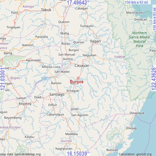
Burgos GPS coordinates[2]
16° 49' 28.56" North, 121° 43' 59.268" East
| Map corner | latitude | longitude |
|---|---|---|
| Upper-left | 17.49642°, | 121.03001° |
| Center: | 16.8246°, | 121.73313° |
| Lower-right: | 16.15039°, | 122.43626° |
| Map W x H: | 149.7×149.7 km | = 93×93mi |
| max Lat: | 20.78733° ⇑7.5% North |
| Burgos: | 16.8246° |
| min Lat: | ⇓92.5% South 4.65442° |
| min Long | Burgos | max Long |
| 117.04868° | 121.73313° | 126.58417° |
| W 36.4%⇐ | ⇒63.6% E |
Elevation
Elevation of Burgos is 73 m = 240 ft, and this is 14.9 m = 49 ft below average elevation for this country.
| Max E: |
2262 m = 7421 ft | 23.8% |
| Avg. | 87.9 m = 288 ft | |
| Burgos | 73 m = 240 ft | |
Min E: |
-2 m = -7 ft | 76.2% |
See also: Philippines elevation on elevation.city.
Geographical zone
Burgos is located in North Torrid zone (between Equator and Tropic of Cancer). Distance of this Northern Tropic circle is 735.2 km =456.8 mi to North.| Distance of | km | miles | from Burgos |
|---|---|---|---|
| North Pole | 8136.3 | 5055.7 | to North |
| Arctic Circle | 5530.5 | 3436.5 | to North |
| Tropic Cancer | 735.2 | 456.8 | to North |
| Equator | 1870.7 | 1162.4 | to South |


Nearby cities:
15 places around Burgos: (largest is in red/bold)
• Alicia
6.3 km =3.9 mi,  217°
217°
• Angadanan
7.9 km =4.9 mi,  168°
168°
• Cauayan
12.9 km =8 mi,  18°
18°
• Diamantina
15.4 km =9.6 mi,  312°
312°
• Echague
14.6 km =9.1 mi,  204°
204°
• Gappal
9.5 km =5.9 mi,  82°
82°
• La Paz
11.8 km =7.3 mi,  324°
324°
• Malasin
5.9 km =3.7 mi,  112°
112°
• Minante Segundo
9.2 km =5.7 mi, 19°
• Nagrumbuan
8.7 km =5.4 mi,  343°
343°
• Pinoma
6.2 km =3.9 mi,  332°
332°
• Salinungan Proper
13.6 km =8.5 mi,  291°
291°
• San Guillermo
13.7 km =8.5 mi,  143°
143°
• Sillawit
6.1 km =3.8 mi,  27°
27°
• Soyung
15.6 km =9.7 mi,  207°
207°
Sources, notices
• [Note1] Compared only with cities in Philippines existing in our database
• [Src1] Map data: © OpenStreetMap contributors (CC-BY-SA)
• [Src2] Other city data from geonames.org with taken over terms of usage.
• [Src3] Geographical zone / Annual Mean Temperature by Robert A. Rohde @ Wikipedia
