Danglas geodata
Danglas (Cordillera) is a seat of a third-order administrative division; located in Philippines in Asia/Manila (GMT+8) time zone. In our database, there are 4166 cities with bigger population. Compared to other cities in Philippines, 97.2% of cities are located further ↓South; 86.2% of cities are located further →East and 81.1% of cities have lower elevation than Danglas. Note1


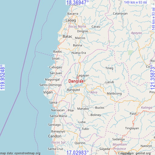
Danglas GPS coordinates[2]
17° 42' 3.24" North, 120° 39' 20.16" East
| Map corner | latitude | longitude |
|---|---|---|
| Upper-left | 18.36947°, | 119.95248° |
| Center: | 17.7009°, | 120.6556° |
| Lower-right: | 17.02983°, | 121.35873° |
| Map W x H: | 149×149 km | = 92.6×92.6mi |
| max Lat: | 20.78733° ⇑2.8% North |
| Danglas: | 17.7009° |
| min Lat: | ⇓97.2% South 4.65442° |
| min Long | Danglas | max Long |
| 117.04868° | 120.6556° | 126.58417° |
| W 13.8%⇐ | ⇒86.2% E |
Elevation
Elevation of Danglas is 100 m = 328 ft, and this is 12.1 m = 40 ft above average elevation for this country.
| Max E: |
2262 m = 7421 ft | 18.9% |
| Danglas | 100 m 328 ft | |
| Avg. | 87.9 m = 288 ft | |
Min E: |
-2 m = -7 ft | 81.1% |
See also: Philippines elevation on elevation.city.
Geographical zone
Danglas is located in North Torrid zone (between Equator and Tropic of Cancer). Distance of this Northern Tropic circle is 637.8 km =396.3 mi to North.| Distance of | km | miles | from Danglas |
|---|---|---|---|
| North Pole | 8038.9 | 4995.1 | to North |
| Arctic Circle | 5433 | 3375.9 | to North |
| Tropic Cancer | 637.8 | 396.3 | to North |
| Equator | 1968.2 | 1223 | to South |


Nearby cities:
15 places around Danglas: (largest is in red/bold)
• Angad
13.3 km =8.3 mi,  193°
193°
• Bangued
10.5 km =6.5 mi, 190°
• Bucay
19.1 km =11.9 mi,  159°
159°
• Calaba
10.1 km =6.3 mi,  204°
204°
• Dolores
8.2 km =5.1 mi,  136°
136°
• La Paz
4.4 km =2.7 mi,  131°
131°
• Lagangilang
13 km =8.1 mi, 139°
• Lagayan
5.8 km =3.6 mi,  67°
67°
• Langiden
16.8 km =10.4 mi,  215°
215°
• Peñarrubia
15.1 km =9.4 mi,  181°
181°
• Pidigan
16.1 km =10 mi,  205°
205°
• San Juan
8.4 km =5.2 mi,  103°
103°
• San Juan
21.4 km =13.3 mi,  282°
282°
• San Quintin
22.7 km =14.1 mi, 219°
• Tayum
9.3 km =5.8 mi, 180°
Sources, notices
• [Note1] Compared only with cities in Philippines existing in our database
• [Src1] Map data: © OpenStreetMap contributors (CC-BY-SA)
• [Src2] Other city data from geonames.org with taken over terms of usage.
• [Src3] Geographical zone / Annual Mean Temperature by Robert A. Rohde @ Wikipedia
