Columbio geodata
Columbio (Soccsksargen) is a seat of a third-order administrative division; located in Philippines in Asia/Manila (GMT+8) time zone. With population of 5,516 people, there are 1153 cities with bigger population in this country. Compared to other cities in Philippines, 94% of cities are located further ↑North; 86.7% of cities are located further ←West and 70% of cities have lower elevation than Columbio. Note1
Administrative division(s):
- Level 1: Soccsksargen
- Level 2: Province of Sultan Kudarat
- Level 3: Columbio


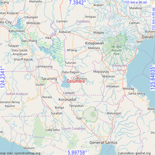
Columbio GPS coordinates[2]
6° 41' 47.004" North, 124° 56' 13.992" East
| Map corner | latitude | longitude |
|---|---|---|
| Upper-left | 7.3942°, | 124.2341° |
| Center: | 6.69639°, | 124.93722° |
| Lower-right: | 5.99758°, | 125.64035° |
| Map W x H: | 155.3×155.3 km | = 96.5×96.5mi |
| max Lat: | 20.78733° ⇑94% North |
| Columbio: | 6.69639° |
| min Lat: | ⇓6% South 4.65442° |
| min Long | Columbio | max Long |
| 117.04868° | 124.93722° | 126.58417° |
| W 86.7%⇐ | ⇒13.3% E |
Elevation
Elevation of Columbio is 52 m = 171 ft, and this is 35.9 m = 118 ft below average elevation for this country.
| Max E: |
2262 m = 7421 ft | 30% |
| Avg. | 87.9 m = 288 ft | |
| Columbio | 52 m = 171 ft | |
Min E: |
-2 m = -7 ft | 70% |
See also: Philippines elevation on elevation.city.
Geographical zone
Columbio is located in North Torrid zone (between Equator and Tropic of Cancer). Distance of Equator is 744.6 km =462.7 mi to South.| Distance of | km | miles | from Columbio |
|---|---|---|---|
| North Pole | 9262.5 | 5755.4 | to North |
| Arctic Circle | 6656.6 | 4136.2 | to North |
| Tropic Cancer | 1861.4 | 1156.6 | to North |
| Equator | 744.6 | 462.7 | to South |


Nearby cities:
15 places around Columbio: (largest is in red/bold)
• Bagontapay
18.3 km =11.4 mi,  350°
350°
• Bayasong
8.8 km =5.5 mi,  233°
233°
• Blingkong
13.1 km =8.1 mi,  203°
203°
• Bual
11.4 km =7.1 mi, 345°
• Buluan
15.2 km =9.4 mi,  280°
280°
• Damawato
17 km =10.6 mi,  271°
271°
• Datu Paglas
12.4 km =7.7 mi,  309°
309°
• Digal
16.8 km =10.4 mi,  292°
292°
• Lutayan
10.6 km =6.6 mi,  215°
215°
• Maindang
15.5 km =9.6 mi, 219°
• Minapan
15.8 km =9.8 mi,  326°
326°
• Paitan
8.3 km =5.2 mi,  240°
240°
• Tamnag
15.1 km =9.4 mi, 204°
• Telafas
8.4 km =5.2 mi,  151°
151°
• Tulunan
16.7 km =10.4 mi,  336°
336°
Sources, notices
• [Note1] Compared only with cities in Philippines existing in our database
• [Src1] Map data: © OpenStreetMap contributors (CC-BY-SA)
• [Src2] Other city data from geonames.org with taken over terms of usage.
• [Src3] Geographical zone / Annual Mean Temperature by Robert A. Rohde @ Wikipedia
