Lutayan geodata
Lutayan (Autonomous Region in Muslim Mindanao) is a populated place; located in Philippines in Asia/Manila (GMT+8) time zone. With population of 13,080 people, there are 491 cities with bigger population in this country. Compared to other cities in Philippines, 94.8% of cities are located further ↑North; 85.9% of cities are located further ←West and 54.4% of cities have lower elevation than Lutayan. Note1
Administrative division(s):
- Level 1: Autonomous Region in Muslim Mindanao
- Level 2: Province of Maguindanao


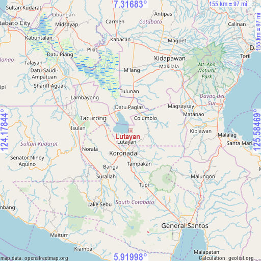
Lutayan GPS coordinates[2]
6° 37' 8.04" North, 124° 52' 53.616" East
| Map corner | latitude | longitude |
|---|---|---|
| Upper-left | 7.31683°, | 124.17844° |
| Center: | 6.6189°, | 124.88156° |
| Lower-right: | 5.91998°, | 125.58469° |
| Map W x H: | 155.3×155.3 km | = 96.5×96.5mi |
| max Lat: | 20.78733° ⇑94.8% North |
| Lutayan: | 6.6189° |
| min Lat: | ⇓5.2% South 4.65442° |
| min Long | Lutayan | max Long |
| 117.04868° | 124.88156° | 126.58417° |
| W 85.9%⇐ | ⇒14.1% E |
Elevation
Elevation of Lutayan is 27 m = 89 ft, and this is 60.9 m = 200 ft below average elevation for this country.
| Max E: |
2262 m = 7421 ft | 45.6% |
| Avg. | 87.9 m = 288 ft | |
| Lutayan | 27 m = 89 ft | |
Min E: |
-2 m = -7 ft | 54.4% |
See also: Philippines elevation on elevation.city.
Geographical zone
Lutayan is located in North Torrid zone (between Equator and Tropic of Cancer). Distance of Equator is 736 km =457.3 mi to South.| Distance of | km | miles | from Lutayan |
|---|---|---|---|
| North Pole | 9271.1 | 5760.8 | to North |
| Arctic Circle | 6665.2 | 4141.6 | to North |
| Tropic Cancer | 1870 | 1162 | to North |
| Equator | 736 | 457.3 | to South |


Nearby cities:
15 places around Lutayan: (largest is in red/bold)
• Bayasong
3.5 km =2.2 mi,  344°
344°
• Blingkong
3.5 km =2.2 mi,  165°
165°
• Bukay Pait
14.2 km =8.8 mi,  243°
243°
• Buluan
14.3 km =8.9 mi,  322°
322°
• Columbio
10.6 km =6.6 mi,  35°
35°
• Damawato
14.1 km =8.8 mi,  309°
309°
• Koronadal
13.4 km =8.3 mi,  196°
196°
• Mabini
12.9 km =8 mi, 166°
• Maibu
11.1 km =6.9 mi, 240°
• Maindang
5 km =3.1 mi,  229°
229°
• New Iloilo
12.9 km =8 mi, 232°
• Paitan
4.7 km =2.9 mi,  346°
346°
• Rotonda
14.1 km =8.8 mi,  177°
177°
• Tamnag
5.1 km =3.2 mi, 181°
• Telafas
10.2 km =6.3 mi,  83°
83°
Sources, notices
• [Note1] Compared only with cities in Philippines existing in our database
• [Src1] Map data: © OpenStreetMap contributors (CC-BY-SA)
• [Src2] Other city data from geonames.org with taken over terms of usage.
• [Src3] Geographical zone / Annual Mean Temperature by Robert A. Rohde @ Wikipedia
