Tamnag geodata
Tamnag (Soccsksargen) is a populated place; located in Philippines in Asia/Manila (GMT+8) time zone. With population of 6,302 people, there are 992 cities with bigger population in this country. Compared to other cities in Philippines, 95.1% of cities are located further ↑North; 85.8% of cities are located further ←West and 68% of cities have lower elevation than Tamnag. Note1
Administrative division(s):
- Level 1: Soccsksargen
- Level 2: Province of Sultan Kudarat
- Level 3: Lutayan


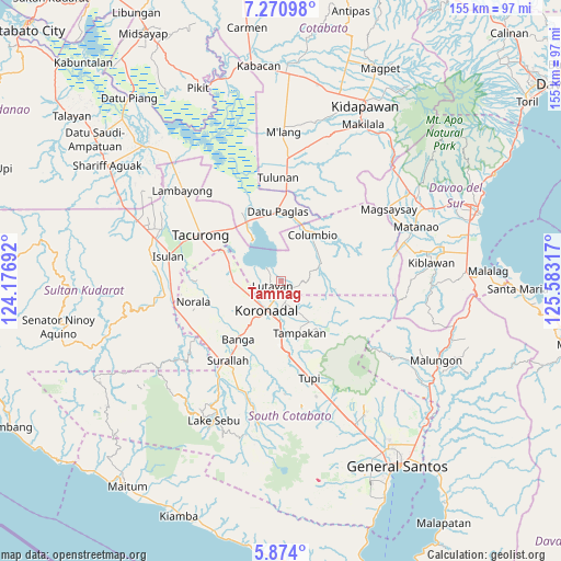
Tamnag GPS coordinates[2]
6° 34' 22.728" North, 124° 52' 48.144" East
| Map corner | latitude | longitude |
|---|---|---|
| Upper-left | 7.27098°, | 124.17692° |
| Center: | 6.57298°, | 124.88004° |
| Lower-right: | 5.874°, | 125.58317° |
| Map W x H: | 155.3×155.3 km | = 96.5×96.5mi |
| max Lat: | 20.78733° ⇑95.1% North |
| Tamnag: | 6.57298° |
| min Lat: | ⇓4.9% South 4.65442° |
| min Long | Tamnag | max Long |
| 117.04868° | 124.88004° | 126.58417° |
| W 85.8%⇐ | ⇒14.2% E |
Elevation
Elevation of Tamnag is 48 m = 157 ft, and this is 39.9 m = 131 ft below average elevation for this country.
| Max E: |
2262 m = 7421 ft | 32% |
| Avg. | 87.9 m = 288 ft | |
| Tamnag | 48 m = 157 ft | |
Min E: |
-2 m = -7 ft | 68% |
See also: Philippines elevation on elevation.city.
Geographical zone
Tamnag is located in North Torrid zone (between Equator and Tropic of Cancer). Distance of Equator is 730.8 km =454.1 mi to South.| Distance of | km | miles | from Tamnag |
|---|---|---|---|
| North Pole | 9276.2 | 5764 | to North |
| Arctic Circle | 6670.3 | 4144.7 | to North |
| Tropic Cancer | 1875.1 | 1165.1 | to North |
| Equator | 730.8 | 454.1 | to South |


Nearby cities:
15 places around Tamnag: (largest is in red/bold)
• Bayasong
8.5 km =5.3 mi,  354°
354°
• Blingkong
2 km =1.2 mi,  31°
31°
• Bukay Pait
12.5 km =7.8 mi,  264°
264°
• Carpenter Hill
14.3 km =8.9 mi,  179°
179°
• Koronadal
8.6 km =5.3 mi,  205°
205°
• Libas
12.3 km =7.6 mi,  241°
241°
• Lutayan
5.1 km =3.2 mi,  1°
1°
• Mabini
8.1 km =5 mi,  157°
157°
• Maibu
9.6 km =6 mi,  268°
268°
• Maindang
4.1 km =2.5 mi,  297°
297°
• New Iloilo
10.4 km =6.5 mi,  254°
254°
• Paitan
9.7 km =6 mi, 354°
• Paraiso
13.3 km =8.3 mi,  215°
215°
• Rotonda
9.1 km =5.7 mi, 175°
• Telafas
12.1 km =7.5 mi,  58°
58°
Sources, notices
• [Note1] Compared only with cities in Philippines existing in our database
• [Src1] Map data: © OpenStreetMap contributors (CC-BY-SA)
• [Src2] Other city data from geonames.org with taken over terms of usage.
• [Src3] Geographical zone / Annual Mean Temperature by Robert A. Rohde @ Wikipedia
