Blingkong geodata
Blingkong (Soccsksargen) is a populated place; located in Philippines in Asia/Manila (GMT+8) time zone. With population of 4,954 people, there are 1313 cities with bigger population in this country. Compared to other cities in Philippines, 95% of cities are located further ↑North; 86.1% of cities are located further ←West and 67.5% of cities have lower elevation than Blingkong. Note1
Administrative division(s):
- Level 1: Soccsksargen
- Level 2: Province of Sultan Kudarat
- Level 3: Lutayan


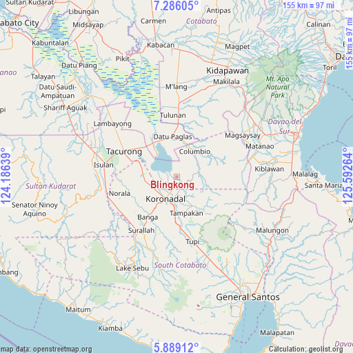
Blingkong GPS coordinates[2]
6° 35' 17.088" North, 124° 53' 22.236" East
| Map corner | latitude | longitude |
|---|---|---|
| Upper-left | 7.28605°, | 124.18639° |
| Center: | 6.58808°, | 124.88951° |
| Lower-right: | 5.88912°, | 125.59264° |
| Map W x H: | 155.3×155.3 km | = 96.5×96.5mi |
| max Lat: | 20.78733° ⇑95% North |
| Blingkong: | 6.58808° |
| min Lat: | ⇓5% South 4.65442° |
| min Long | Blingkong | max Long |
| 117.04868° | 124.88951° | 126.58417° |
| W 86.1%⇐ | ⇒13.9% E |
Elevation
Elevation of Blingkong is 47 m = 154 ft, and this is 40.9 m = 134 ft below average elevation for this country.
| Max E: |
2262 m = 7421 ft | 32.5% |
| Avg. | 87.9 m = 288 ft | |
| Blingkong | 47 m = 154 ft | |
Min E: |
-2 m = -7 ft | 67.5% |
See also: Philippines elevation on elevation.city.
Geographical zone
Blingkong is located in North Torrid zone (between Equator and Tropic of Cancer). Distance of Equator is 732.5 km =455.2 mi to South.| Distance of | km | miles | from Blingkong |
|---|---|---|---|
| North Pole | 9274.5 | 5762.9 | to North |
| Arctic Circle | 6668.6 | 4143.7 | to North |
| Tropic Cancer | 1873.4 | 1164.1 | to North |
| Equator | 732.5 | 455.2 | to South |


Nearby cities:
15 places around Blingkong: (largest is in red/bold)
• Bayasong
7 km =4.3 mi,  344°
344°
• Bukay Pait
13.8 km =8.6 mi,  257°
257°
• Columbio
13.1 km =8.1 mi,  23°
23°
• Koronadal
10.6 km =6.6 mi,  206°
206°
• Libas
14 km =8.7 mi,  237°
237°
• Lutayan
3.5 km =2.2 mi,  345°
345°
• Mabini
9.4 km =5.8 mi,  167°
167°
• Maibu
10.8 km =6.7 mi, 259°
• Maindang
4.7 km =2.9 mi,  272°
272°
• New Iloilo
11.9 km =7.4 mi,  247°
247°
• Paitan
8.2 km =5.1 mi, 346°
• Paraiso
15.3 km =9.5 mi,  215°
215°
• Rotonda
10.7 km =6.6 mi,  181°
181°
• Tamnag
2 km =1.2 mi, 211°
• Telafas
10.3 km =6.4 mi,  63°
63°
Sources, notices
• [Note1] Compared only with cities in Philippines existing in our database
• [Src1] Map data: © OpenStreetMap contributors (CC-BY-SA)
• [Src2] Other city data from geonames.org with taken over terms of usage.
• [Src3] Geographical zone / Annual Mean Temperature by Robert A. Rohde @ Wikipedia
