Cauayan geodata
Cauayan (Cagayan Valley) is a seat of a third-order administrative division; located in Philippines in Asia/Manila (GMT+8) time zone. In our database, there are 4166 cities with bigger population. Compared to other cities in Philippines, 93.1% of cities are located further ↓South; 63% of cities are located further →East and 73.6% of cities have lower elevation than Cauayan. Note1
Administrative division(s):
- Level 1: Cagayan Valley
- Level 2: Province of Isabela
- Level 3: City of Cauayan


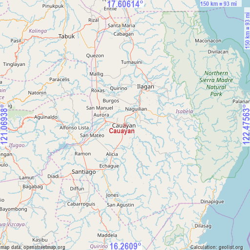
Cauayan GPS coordinates[2]
16° 56' 4.992" North, 121° 46' 21" East
| Map corner | latitude | longitude |
|---|---|---|
| Upper-left | 17.60614°, | 121.06938° |
| Center: | 16.93472°, | 121.7725° |
| Lower-right: | 16.2609°, | 122.47563° |
| Map W x H: | 149.6×149.6 km | = 93×93mi |
| max Lat: | 20.78733° ⇑6.9% North |
| Cauayan: | 16.93472° |
| min Lat: | ⇓93.1% South 4.65442° |
| min Long | Cauayan | max Long |
| 117.04868° | 121.7725° | 126.58417° |
| W 37%⇐ | ⇒63% E |
Elevation
Elevation of Cauayan is 63 m = 207 ft, and this is 24.9 m = 82 ft below average elevation for this country.
| Max E: |
2262 m = 7421 ft | 26.4% |
| Avg. | 87.9 m = 288 ft | |
| Cauayan | 63 m = 207 ft | |
Min E: |
-2 m = -7 ft | 73.6% |
See also: Philippines elevation on elevation.city.
Geographical zone
Cauayan is located in North Torrid zone (between Equator and Tropic of Cancer). Distance of this Northern Tropic circle is 723 km =449.3 mi to North.| Distance of | km | miles | from Cauayan |
|---|---|---|---|
| North Pole | 8124.1 | 5048.1 | to North |
| Arctic Circle | 5518.2 | 3428.8 | to North |
| Tropic Cancer | 723 | 449.3 | to North |
| Equator | 1883 | 1170 | to South |


Nearby cities:
15 places around Cauayan: (largest is in red/bold)
• Banquero
9.8 km =6.1 mi,  3°
3°
• Cabatuan
11.3 km =7 mi,  282°
282°
• Furao
11.4 km =7.1 mi,  13°
13°
• Gappal
12.1 km =7.5 mi,  154°
154°
• La Paz
11.4 km =7.1 mi,  256°
256°
• Luna
6 km =3.7 mi,  310°
310°
• Magdalena
11.5 km =7.1 mi, 279°
• Minallo
10.4 km =6.5 mi,  56°
56°
• Minante Segundo
3.8 km =2.4 mi,  197°
197°
• Nagrumbuan
7.7 km =4.8 mi,  239°
239°
• Naguilian
12 km =7.5 mi,  34°
34°
• Pinoma
9.7 km =6 mi,  226°
226°
• Reina Mercedes
8.1 km =5 mi,  45°
45°
• San Luis
6.8 km =4.2 mi, 60°
• Sillawit
7 km =4.3 mi,  191°
191°
Sources, notices
• [Note1] Compared only with cities in Philippines existing in our database
• [Src1] Map data: © OpenStreetMap contributors (CC-BY-SA)
• [Src2] Other city data from geonames.org with taken over terms of usage.
• [Src3] Geographical zone / Annual Mean Temperature by Robert A. Rohde @ Wikipedia
