Nagrumbuan geodata
Nagrumbuan (Cagayan Valley) is a populated place; located in Philippines in Asia/Manila (GMT+8) time zone. With population of 3,547 people, there are 2022 cities with bigger population in this country. Compared to other cities in Philippines, 92.9% of cities are located further ↓South; 63.9% of cities are located further →East and 74.6% of cities have lower elevation than Nagrumbuan. Note1
Administrative division(s):
- Level 1: Cagayan Valley
- Level 2: Province of Isabela
- Level 3: City of Cauayan


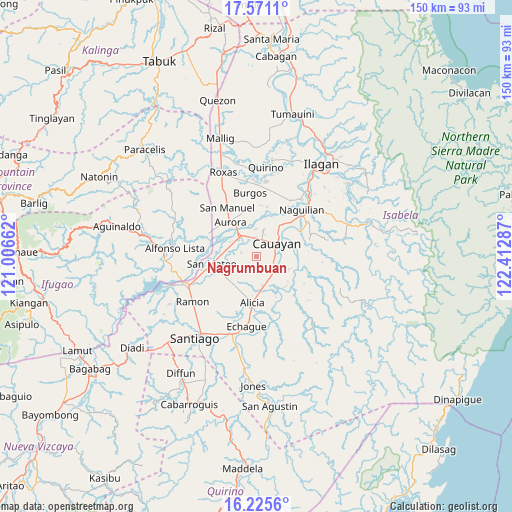
Nagrumbuan GPS coordinates[2]
16° 53' 58.38" North, 121° 42' 35.064" East
| Map corner | latitude | longitude |
|---|---|---|
| Upper-left | 17.5711°, | 121.00662° |
| Center: | 16.89955°, | 121.70974° |
| Lower-right: | 16.2256°, | 122.41287° |
| Map W x H: | 149.6×149.6 km | = 93×93mi |
| max Lat: | 20.78733° ⇑7.1% North |
| Nagrumbuan: | 16.89955° |
| min Lat: | ⇓92.9% South 4.65442° |
| min Long | Nagrumbuan | max Long |
| 117.04868° | 121.70974° | 126.58417° |
| W 36.1%⇐ | ⇒63.9% E |
Elevation
Elevation of Nagrumbuan is 67 m = 220 ft, and this is 20.9 m = 69 ft below average elevation for this country.
| Max E: |
2262 m = 7421 ft | 25.4% |
| Avg. | 87.9 m = 288 ft | |
| Nagrumbuan | 67 m = 220 ft | |
Min E: |
-2 m = -7 ft | 74.6% |
See also: Philippines elevation on elevation.city.
Geographical zone
Nagrumbuan is located in North Torrid zone (between Equator and Tropic of Cancer). Distance of this Northern Tropic circle is 726.9 km =451.7 mi to North.| Distance of | km | miles | from Nagrumbuan |
|---|---|---|---|
| North Pole | 8128 | 5050.5 | to North |
| Arctic Circle | 5522.1 | 3431.3 | to North |
| Tropic Cancer | 726.9 | 451.7 | to North |
| Equator | 1879.1 | 1167.6 | to South |


Nearby cities:
15 places around Nagrumbuan: (largest is in red/bold)
• Alicia
13.4 km =8.3 mi,  185°
185°
• Aurora
12.8 km =8 mi,  322°
322°
• Burgos
8.7 km =5.4 mi,  163°
163°
• Cabatuan
7.7 km =4.8 mi,  325°
325°
• Cauayan
7.7 km =4.8 mi,  59°
59°
• Diamantina
9.1 km =5.7 mi,  283°
283°
• La Paz
4.6 km =2.9 mi,  285°
285°
• Luna
8.1 km =5 mi,  14°
14°
• Magdalena
7.5 km =4.7 mi, 321°
• Malasin
13.2 km =8.2 mi,  143°
143°
• Minante Segundo
5.6 km =3.5 mi,  86°
86°
• Pinoma
2.8 km =1.7 mi, 186°
• Salinungan Proper
10.7 km =6.6 mi,  251°
251°
• San Mateo
13.2 km =8.2 mi,  261°
261°
• Sillawit
6 km =3.7 mi,  119°
119°
Sources, notices
• [Note1] Compared only with cities in Philippines existing in our database
• [Src1] Map data: © OpenStreetMap contributors (CC-BY-SA)
• [Src2] Other city data from geonames.org with taken over terms of usage.
• [Src3] Geographical zone / Annual Mean Temperature by Robert A. Rohde @ Wikipedia
