Pinoma geodata
Pinoma (Cagayan Valley) is a populated place; located in Philippines in Asia/Manila (GMT+8) time zone. With population of 3,305 people, there are 2217 cities with bigger population in this country. Compared to other cities in Philippines, 92.7% of cities are located further ↓South; 63.9% of cities are located further →East and 75.3% of cities have lower elevation than Pinoma. Note1
Administrative division(s):
- Level 1: Cagayan Valley
- Level 2: Province of Isabela
- Level 3: City of Cauayan


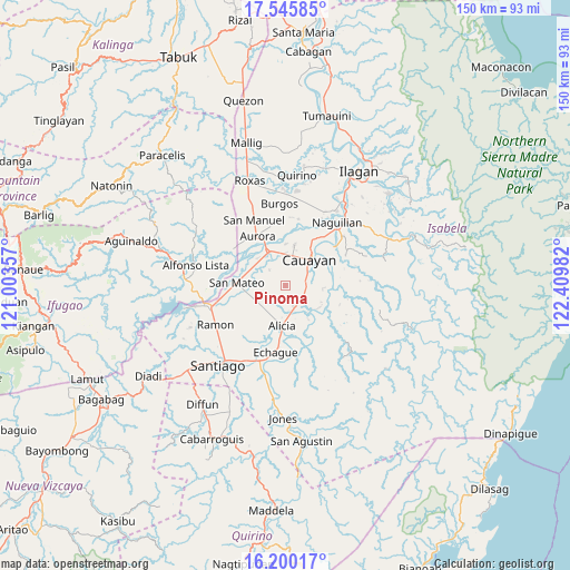
Pinoma GPS coordinates[2]
16° 52' 27.156" North, 121° 42' 24.084" East
| Map corner | latitude | longitude |
|---|---|---|
| Upper-left | 17.54585°, | 121.00357° |
| Center: | 16.87421°, | 121.70669° |
| Lower-right: | 16.20017°, | 122.40982° |
| Map W x H: | 149.6×149.6 km | = 93×93mi |
| max Lat: | 20.78733° ⇑7.3% North |
| Pinoma: | 16.87421° |
| min Lat: | ⇓92.7% South 4.65442° |
| min Long | Pinoma | max Long |
| 117.04868° | 121.70669° | 126.58417° |
| W 36.1%⇐ | ⇒63.9% E |
Elevation
Elevation of Pinoma is 69 m = 226 ft, and this is 18.9 m = 62 ft below average elevation for this country.
| Max E: |
2262 m = 7421 ft | 24.7% |
| Avg. | 87.9 m = 288 ft | |
| Pinoma | 69 m = 226 ft | |
Min E: |
-2 m = -7 ft | 75.3% |
See also: Philippines elevation on elevation.city.
Geographical zone
Pinoma is located in North Torrid zone (between Equator and Tropic of Cancer). Distance of this Northern Tropic circle is 729.7 km =453.4 mi to North.| Distance of | km | miles | from Pinoma |
|---|---|---|---|
| North Pole | 8130.8 | 5052.2 | to North |
| Arctic Circle | 5524.9 | 3433 | to North |
| Tropic Cancer | 729.7 | 453.4 | to North |
| Equator | 1876.2 | 1165.8 | to South |


Nearby cities:
15 places around Pinoma: (largest is in red/bold)
• Alicia
10.6 km =6.6 mi,  185°
185°
• Burgos
6.2 km =3.9 mi,  152°
152°
• Cabatuan
10 km =6.2 mi,  336°
336°
• Cauayan
9.7 km =6 mi,  46°
46°
• Diamantina
9.8 km =6.1 mi,  299°
299°
• Gappal
13 km =8.1 mi,  108°
108°
• La Paz
5.8 km =3.6 mi,  314°
314°
• Luna
10.9 km =6.8 mi,  12°
12°
• Magdalena
9.7 km =6 mi,  333°
333°
• Malasin
11.3 km =7 mi,  133°
133°
• Minante Segundo
6.6 km =4.1 mi,  62°
62°
• Nagrumbuan
2.8 km =1.7 mi, 6°
• Salinungan Proper
9.8 km =6.1 mi,  266°
266°
• San Mateo
12.8 km =8 mi, 273°
• Sillawit
5.6 km =3.5 mi,  91°
91°
Sources, notices
• [Note1] Compared only with cities in Philippines existing in our database
• [Src1] Map data: © OpenStreetMap contributors (CC-BY-SA)
• [Src2] Other city data from geonames.org with taken over terms of usage.
• [Src3] Geographical zone / Annual Mean Temperature by Robert A. Rohde @ Wikipedia
