La Paz geodata
La Paz (Cagayan Valley) is a populated place; located in Philippines in Asia/Manila (GMT+8) time zone. With population of 4,017 people, there are 1714 cities with bigger population in this country. Compared to other cities in Philippines, 93% of cities are located further ↓South; 64.5% of cities are located further →East and 74.1% of cities have lower elevation than La Paz. Note1


La Paz GPS coordinates[2]
16° 54' 38.7" North, 121° 40' 5.664" East
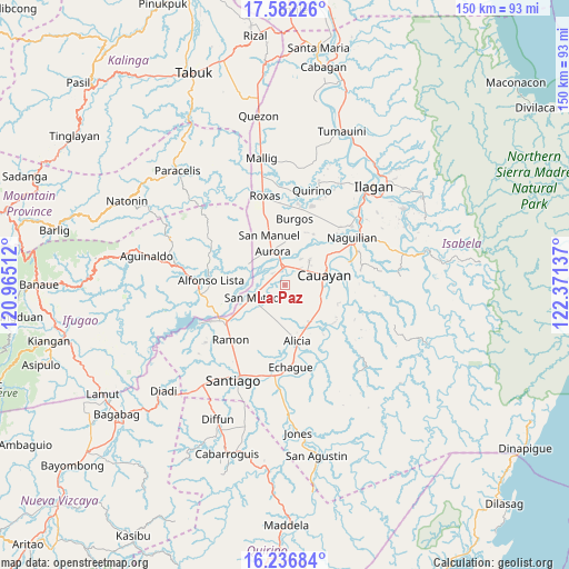
| Map corner | latitude | longitude |
|---|---|---|
| Upper-left | 17.58226°, | 120.96512° |
| Center: | 16.91075°, | 121.66824° |
| Lower-right: | 16.23684°, | 122.37137° |
| Map W x H: | 149.6×149.6 km | = 93×93mi |
| max Lat: | 20.78733° ⇑7% North |
| La Paz: | 16.91075° |
| min Lat: | ⇓93% South 4.65442° |
| min Long | La Paz | max Long |
| 117.04868° | 121.66824° | 126.58417° |
| W 35.5%⇐ | ⇒64.5% E |
Elevation
Elevation of La Paz is 65 m = 213 ft, and this is 22.9 m = 75 ft below average elevation for this country.
| Max E: |
2262 m = 7421 ft | 25.9% |
| Avg. | 87.9 m = 288 ft | |
| La Paz | 65 m = 213 ft | |
Min E: |
-2 m = -7 ft | 74.1% |
See also: Philippines elevation on elevation.city.
Geographical zone
La Paz is located in North Torrid zone (between Equator and Tropic of Cancer). Distance of this Northern Tropic circle is 725.6 km =450.9 mi to North.| Distance of | km | miles | from La Paz |
|---|---|---|---|
| North Pole | 8126.8 | 5049.8 | to North |
| Arctic Circle | 5520.9 | 3430.5 | to North |
| Tropic Cancer | 725.6 | 450.9 | to North |
| Equator | 1880.3 | 1168.4 | to South |


Nearby cities:
15 places around La Paz: (largest is in red/bold)
• Aurora
9.5 km =5.9 mi,  339°
339°
• Bagong Tanza
10 km =6.2 mi,  322°
322°
• Burgos
11.8 km =7.3 mi,  144°
144°
• Cabatuan
5.1 km =3.2 mi,  0°
0°
• Cauayan
11.4 km =7.1 mi,  76°
76°
• Diamantina
4.5 km =2.8 mi,  280°
280°
• Luna
9.2 km =5.7 mi,  44°
44°
• Magdalena
4.6 km =2.9 mi,  356°
356°
• Minante Segundo
10 km =6.2 mi,  95°
95°
• Nagrumbuan
4.6 km =2.9 mi,  105°
105°
• Pinoma
5.8 km =3.6 mi,  134°
134°
• Salinungan Proper
7.4 km =4.6 mi,  230°
230°
• San Mateo
9.2 km =5.7 mi,  249°
249°
• Sillawit
10.5 km =6.5 mi, 113°
• Sinamar
10.9 km =6.8 mi,  263°
263°
Sources, notices
• [Note1] Compared only with cities in Philippines existing in our database
• [Src1] Map data: © OpenStreetMap contributors (CC-BY-SA)
• [Src2] Other city data from geonames.org with taken over terms of usage.
• [Src3] Geographical zone / Annual Mean Temperature by Robert A. Rohde @ Wikipedia
