Ballesteros geodata
Ballesteros (Cagayan Valley) is a seat of a third-order administrative division; located in Philippines in Asia/Manila (GMT+8) time zone. With population of 5,591 people, there are 1135 cities with bigger population in this country. Compared to other cities in Philippines, 99.5% of cities are located further ↓South; 66.2% of cities are located further →East and 89.7% of cities have higher elevation than Ballesteros. Note1
Administrative division(s):
- Level 1: Cagayan Valley
- Level 2: Province of Cagayan
- Level 3: Ballesteros


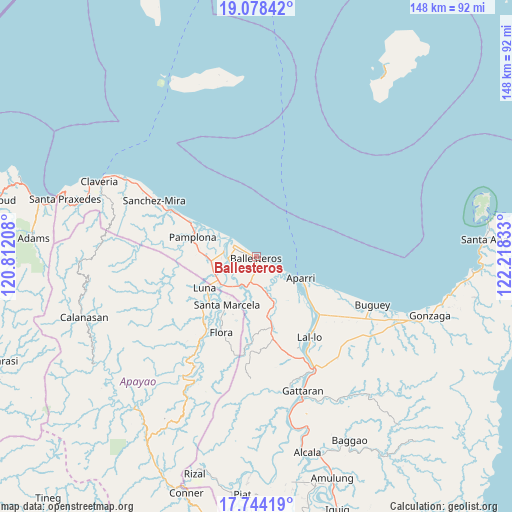
Ballesteros GPS coordinates[2]
18° 24' 45.36" North, 121° 30' 54.72" East
| Map corner | latitude | longitude |
|---|---|---|
| Upper-left | 19.07842°, | 120.81208° |
| Center: | 18.4126°, | 121.5152° |
| Lower-right: | 17.74419°, | 122.21833° |
| Map W x H: | 148.4×148.4 km | = 92.2×92.2mi |
| max Lat: | 20.78733° ⇑0.5% North |
| Ballesteros: | 18.4126° |
| min Lat: | ⇓99.5% South 4.65442° |
| min Long | Ballesteros | max Long |
| 117.04868° | 121.5152° | 126.58417° |
| W 33.8%⇐ | ⇒66.2% E |
Elevation
Elevation of Ballesteros is 7 m = 23 ft, and this is 80.9 m = 265 ft below average elevation for this country.
| Max E: |
2262 m = 7421 ft | 89.7% |
| Avg. | 87.9 m = 288 ft | |
| Ballesteros | 7 m = 23 ft | |
Min E: |
-2 m = -7 ft | 10.3% |
See also: Philippines elevation on elevation.city.
Geographical zone
Ballesteros is located in North Torrid zone (between Equator and Tropic of Cancer). Distance of this Northern Tropic circle is 558.6 km =347.1 mi to North.| Distance of | km | miles | from Ballesteros |
|---|---|---|---|
| North Pole | 7959.8 | 4946 | to North |
| Arctic Circle | 5353.9 | 3326.8 | to North |
| Tropic Cancer | 558.6 | 347.1 | to North |
| Equator | 2047.3 | 1272.1 | to South |


Nearby cities:
15 places around Ballesteros: (largest is in red/bold)
• Abulug
7.5 km =4.7 mi,  299°
299°
• Allacapan
21.2 km =13.2 mi,  168°
168°
• Aparri
14.6 km =9.1 mi,  115°
115°
• Bagu
16.9 km =10.5 mi,  274°
274°
• Binalan
10 km =6.2 mi,  161°
161°
• Cabaritan East
2.9 km =1.8 mi,  281°
281°
• Calog Norte
14.7 km =9.1 mi,  248°
248°
• Camalaniugan
22.8 km =14.2 mi,  132°
132°
• Flora
24.1 km =15 mi,  205°
205°
• Guiddam
10.1 km =6.3 mi, 210°
• Lucban
12.3 km =7.6 mi,  226°
226°
• Luna
19.6 km =12.2 mi,  240°
240°
• Mabuttal East
4 km =2.5 mi,  180°
180°
• Pamplona
19.3 km =12 mi,  288°
288°
• Santa Marcela
16.8 km =10.4 mi, 211°
Sources, notices
• [Note1] Compared only with cities in Philippines existing in our database
• [Src1] Map data: © OpenStreetMap contributors (CC-BY-SA)
• [Src2] Other city data from geonames.org with taken over terms of usage.
• [Src3] Geographical zone / Annual Mean Temperature by Robert A. Rohde @ Wikipedia
