Calumpang geodata
Calumpang (Metro Manila) is a populated place; located in Philippines in Asia/Manila (GMT+8) time zone. With population of 15,589 people, there are 432 cities with bigger population in this country. Compared to other cities in Philippines, 74.7% of cities are located further ↓South; 74.1% of cities are located further →East and 70.2% of cities have higher elevation than Calumpang. Note1
Administrative division(s):
- Level 1: Metro Manila
- Level 2: Eastern Manila District
- Level 3: City of Marikina


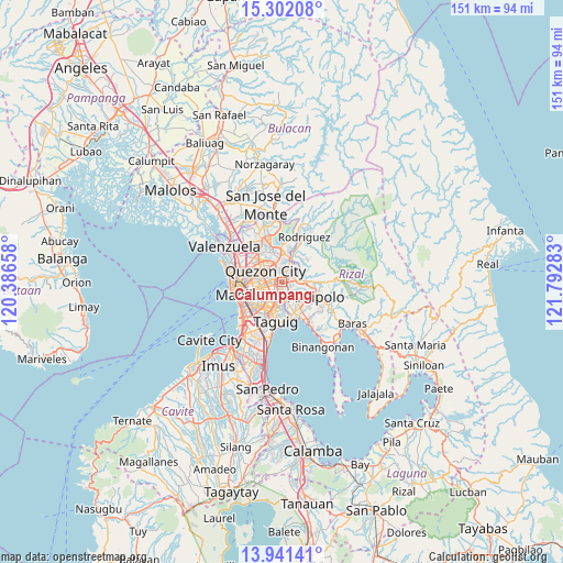
Calumpang GPS coordinates[2]
14° 37' 22.08" North, 121° 5' 22.92" East
| Map corner | latitude | longitude |
|---|---|---|
| Upper-left | 15.30208°, | 120.38658° |
| Center: | 14.6228°, | 121.0897° |
| Lower-right: | 13.94141°, | 121.79283° |
| Map W x H: | 151.3×151.3 km | = 94×94mi |
| max Lat: | 20.78733° ⇑25.3% North |
| Calumpang: | 14.6228° |
| min Lat: | ⇓74.7% South 4.65442° |
| min Long | Calumpang | max Long |
| 117.04868° | 121.0897° | 126.58417° |
| W 25.9%⇐ | ⇒74.1% E |
Elevation
Elevation of Calumpang is 12 m = 39 ft, and this is 75.9 m = 249 ft below average elevation for this country.
| Max E: |
2262 m = 7421 ft | 70.2% |
| Avg. | 87.9 m = 288 ft | |
| Calumpang | 12 m = 39 ft | |
Min E: |
-2 m = -7 ft | 29.8% |
See also: Philippines elevation on elevation.city.
Geographical zone
Calumpang is located in North Torrid zone (between Equator and Tropic of Cancer). Distance of this Northern Tropic circle is 980 km =608.9 mi to North.| Distance of | km | miles | from Calumpang |
|---|---|---|---|
| North Pole | 8381.2 | 5207.8 | to North |
| Arctic Circle | 5775.3 | 3588.6 | to North |
| Tropic Cancer | 980 | 608.9 | to North |
| Equator | 1625.9 | 1010.3 | to South |


Nearby cities:
15 places around Calumpang: (largest is in red/bold)
• Antipolo
3.5 km =2.2 mi,  84°
84°
• Bagong Pagasa
7.6 km =4.7 mi,  305°
305°
• Cainta
6 km =3.7 mi,  144°
144°
• Del Monte
8 km =5 mi,  285°
285°
• Makati City
10.1 km =6.3 mi,  217°
217°
• Malanday
10.3 km =6.4 mi,  25°
25°
• Mandaluyong City
6.9 km =4.3 mi,  230°
230°
• Pasig City
5 km =3.1 mi, 217°
• Pateros
9.5 km =5.9 mi,  191°
191°
• Quezon City
5.1 km =3.2 mi,  304°
304°
• Quiapo
11.7 km =7.3 mi,  257°
257°
• San Juan
6.6 km =4.1 mi,  247°
247°
• San Mateo
9.1 km =5.7 mi,  23°
23°
• Taguig
11 km =6.8 mi, 185°
• Taytay
8.5 km =5.3 mi,  146°
146°
Sources, notices
• [Note1] Compared only with cities in Philippines existing in our database
• [Src1] Map data: © OpenStreetMap contributors (CC-BY-SA)
• [Src2] Other city data from geonames.org with taken over terms of usage.
• [Src3] Geographical zone / Annual Mean Temperature by Robert A. Rohde @ Wikipedia
