Los Baños geodata
Los Baños (Calabarzon) is a seat of a third-order administrative division; located in Philippines in Asia/Manila (GMT+8) time zone. With population of 95,750 people, there are 96 cities with bigger population in this country. Compared to other cities in Philippines, 71.4% of cities are located further ↓South; 70.9% of cities are located further →East and 58.8% of cities have lower elevation than Los Baños. Note1


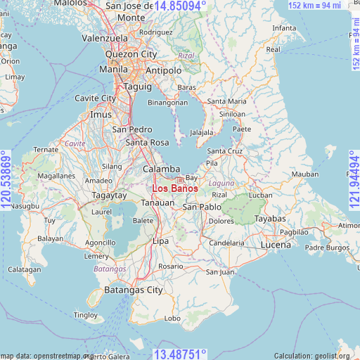
Los Baños GPS coordinates[2]
14° 10' 12.9" North, 121° 14' 30.516" East
| Map corner | latitude | longitude |
|---|---|---|
| Upper-left | 14.85094°, | 120.53869° |
| Center: | 14.17025°, | 121.24181° |
| Lower-right: | 13.48751°, | 121.94494° |
| Map W x H: | 151.6×151.6 km | = 94.2×94.2mi |
| max Lat: | 20.78733° ⇑28.6% North |
| Los Baños: | 14.17025° |
| min Lat: | ⇓71.4% South 4.65442° |
| min Long | Los Baños | max Long |
| 117.04868° | 121.24181° | 126.58417° |
| W 29.1%⇐ | ⇒70.9% E |
Elevation
Elevation of Los Baños is 32 m = 105 ft, and this is 55.9 m = 183 ft below average elevation for this country.
| Max E: |
2262 m = 7421 ft | 41.2% |
| Avg. | 87.9 m = 288 ft | |
| Los Baños | 32 m = 105 ft | |
Min E: |
-2 m = -7 ft | 58.8% |
See also: Los Baños elevation on elevation.city.
Geographical zone
Los Baños is located in North Torrid zone (between Equator and Tropic of Cancer). Distance of this Northern Tropic circle is 1030.3 km =640.2 mi to North.| Distance of | km | miles | from Los Baños |
|---|---|---|---|
| North Pole | 8431.5 | 5239.1 | to North |
| Arctic Circle | 5825.6 | 3619.9 | to North |
| Tropic Cancer | 1030.3 | 640.2 | to North |
| Equator | 1575.6 | 979 | to South |


Nearby cities:
15 places around Los Baños: (largest is in red/bold)
• Alaminos
11.8 km =7.3 mi,  177°
177°
• Bay
4.9 km =3 mi,  72°
72°
• Bitin
6.4 km =4 mi,  199°
199°
• Calamba
9.4 km =5.8 mi,  299°
299°
• Calauan
8.2 km =5.1 mi,  105°
105°
• Dayap
9.9 km =6.2 mi,  83°
83°
• Hanggan
6.6 km =4.1 mi, 71°
• Mamatid
11.5 km =7.1 mi,  308°
308°
• Masapang
11.2 km =7 mi, 74°
• Masaya
4.8 km =3 mi,  115°
115°
• Prinza
11.7 km =7.3 mi,  284°
284°
• San Juan
12.6 km =7.8 mi,  186°
186°
• Santa Catalina
12.1 km =7.5 mi, 116°
• Santa Cruz
7.5 km =4.7 mi,  143°
143°
• Victoria
11.4 km =7.1 mi,  55°
55°
Sources, notices
• [Note1] Compared only with cities in Philippines existing in our database
• [Src1] Map data: © OpenStreetMap contributors (CC-BY-SA)
• [Src2] Other city data from geonames.org with taken over terms of usage.
• [Src3] Geographical zone / Annual Mean Temperature by Robert A. Rohde @ Wikipedia
