Daguioman geodata
Daguioman (Cordillera) is a seat of a third-order administrative division; located in Philippines in Asia/Manila (GMT+8) time zone. In our database, there are 4166 cities with bigger population. Compared to other cities in Philippines, 95.9% of cities are located further ↓South; 79% of cities are located further →East and 95.4% of cities have lower elevation than Daguioman. Note1


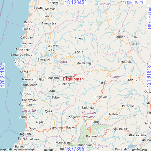
Daguioman GPS coordinates[2]
17° 27' 3.348" North, 120° 54' 54.18" East
| Map corner | latitude | longitude |
|---|---|---|
| Upper-left | 18.12045°, | 120.21193° |
| Center: | 17.45093°, | 120.91505° |
| Lower-right: | 16.77895°, | 121.61818° |
| Map W x H: | 149.2×149.2 km | = 92.7×92.7mi |
| max Lat: | 20.78733° ⇑4.1% North |
| Daguioman: | 17.45093° |
| min Lat: | ⇓95.9% South 4.65442° |
| min Long | Daguioman | max Long |
| 117.04868° | 120.91505° | 126.58417° |
| W 21%⇐ | ⇒79% E |
Elevation
Elevation of Daguioman is 444 m = 1457 ft, and this is 356.1 m = 1168 ft above average elevation for this country.
| Max E: |
2262 m = 7421 ft | 4.6% |
| Daguioman | 444 m 1457 ft | |
| Avg. | 87.9 m = 288 ft | |
Min E: |
-2 m = -7 ft | 95.4% |
See also: Philippines elevation on elevation.city.
Geographical zone
Daguioman is located in North Torrid zone (between Equator and Tropic of Cancer). Distance of this Northern Tropic circle is 665.6 km =413.6 mi to North.| Distance of | km | miles | from Daguioman |
|---|---|---|---|
| North Pole | 8066.7 | 5012.4 | to North |
| Arctic Circle | 5460.8 | 3393.2 | to North |
| Tropic Cancer | 665.6 | 413.6 | to North |
| Equator | 1940.4 | 1205.7 | to South |


Nearby cities:
15 places around Daguioman: (largest is in red/bold)
• Balbalan
30.5 km =19 mi,  91°
91°
• Bantay
16.7 km =10.4 mi,  265°
265°
• Boliney
15 km =9.3 mi,  251°
251°
• Bucay
23.1 km =14.4 mi,  295°
295°
• Bucloc
6.1 km =3.8 mi,  259°
259°
• Lagangilang
26.2 km =16.3 mi,  313°
313°
• Licuan
17.6 km =10.9 mi,  356°
356°
• Luba
27.7 km =17.2 mi,  237°
237°
• Lubuagan
29.5 km =18.3 mi,  111°
111°
• Manabo
22.3 km =13.9 mi, 264°
• Pasil
24.3 km =15.1 mi, 107°
• Peñarrubia
30.6 km =19 mi,  294°
294°
• San Ramon
22.4 km =13.9 mi, 259°
• Tubo
28 km =17.4 mi,  222°
222°
• Villaviciosa
30.7 km =19.1 mi, 267°
Sources, notices
• [Note1] Compared only with cities in Philippines existing in our database
• [Src1] Map data: © OpenStreetMap contributors (CC-BY-SA)
• [Src2] Other city data from geonames.org with taken over terms of usage.
• [Src3] Geographical zone / Annual Mean Temperature by Robert A. Rohde @ Wikipedia
