Dagup geodata
Dagup (Ilocos) is a populated place; located in Philippines in Asia/Manila (GMT+8) time zone. With population of 2,090 people, there are 4087 cities with bigger population in this country. Compared to other cities in Philippines, 91.6% of cities are located further ↓South; 92.3% of cities are located further →East and 95.3% of cities have lower elevation than Dagup. Note1


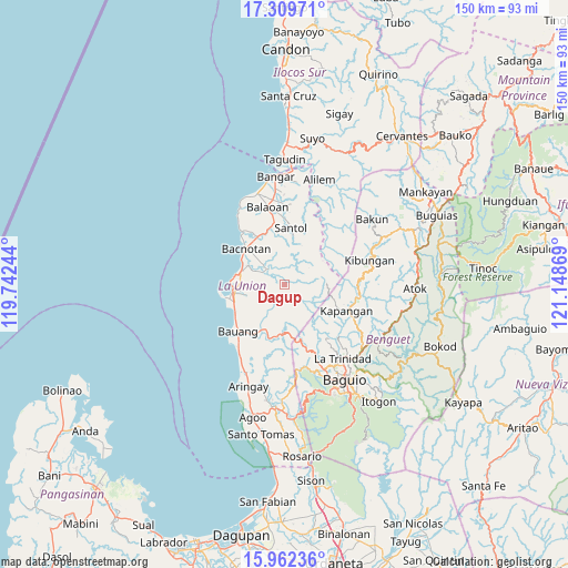
Dagup GPS coordinates[2]
16° 38' 13.992" North, 120° 26' 44.016" East
| Map corner | latitude | longitude |
|---|---|---|
| Upper-left | 17.30971°, | 119.74244° |
| Center: | 16.63722°, | 120.44556° |
| Lower-right: | 15.96236°, | 121.14869° |
| Map W x H: | 149.8×149.8 km | = 93.1×93.1mi |
| max Lat: | 20.78733° ⇑8.4% North |
| Dagup: | 16.63722° |
| min Lat: | ⇓91.6% South 4.65442° |
| min Long | Dagup | max Long |
| 117.04868° | 120.44556° | 126.58417° |
| W 7.7%⇐ | ⇒92.3% E |
Elevation
Elevation of Dagup is 439 m = 1440 ft, and this is 351.1 m = 1152 ft above average elevation for this country.
| Max E: |
2262 m = 7421 ft | 4.7% |
| Dagup | 439 m 1440 ft | |
| Avg. | 87.9 m = 288 ft | |
Min E: |
-2 m = -7 ft | 95.3% |
See also: Philippines elevation on elevation.city.
Geographical zone
Dagup is located in North Torrid zone (between Equator and Tropic of Cancer). Distance of this Northern Tropic circle is 756 km =469.8 mi to North.| Distance of | km | miles | from Dagup |
|---|---|---|---|
| North Pole | 8157.2 | 5068.6 | to North |
| Arctic Circle | 5551.3 | 3449.4 | to North |
| Tropic Cancer | 756 | 469.8 | to North |
| Equator | 1849.9 | 1149.5 | to South |


Nearby cities:
15 places around Dagup: (largest is in red/bold)
• Acao
14.4 km =8.9 mi,  210°
210°
• Bacnotan
13.7 km =8.5 mi,  313°
313°
• Bagulin
3.3 km =2.1 mi,  191°
191°
• Bauang
16.8 km =10.4 mi,  225°
225°
• Burgos
13.3 km =8.3 mi,  172°
172°
• Butubut Norte
18.5 km =11.5 mi,  356°
356°
• Corrooy
17.7 km =11 mi, 359°
• Kapangan
17.6 km =10.9 mi,  113°
113°
• Naguilian
12.6 km =7.8 mi,  204°
204°
• Paringao
14.8 km =9.2 mi,  240°
240°
• Sablan
16.9 km =10.5 mi,  161°
161°
• San Fernando
13.9 km =8.6 mi,  260°
260°
• San Gabriel
6.2 km =3.9 mi, 313°
• San Juan
11.6 km =7.2 mi,  287°
287°
• Santol
15.1 km =9.4 mi,  6°
6°
Sources, notices
• [Note1] Compared only with cities in Philippines existing in our database
• [Src1] Map data: © OpenStreetMap contributors (CC-BY-SA)
• [Src2] Other city data from geonames.org with taken over terms of usage.
• [Src3] Geographical zone / Annual Mean Temperature by Robert A. Rohde @ Wikipedia
