Bagulin geodata
Bagulin (Ilocos) is a seat of a third-order administrative division; located in Philippines in Asia/Manila (GMT+8) time zone. With population of 2,083 people, there are 4096 cities with bigger population in this country. Compared to other cities in Philippines, 91.5% of cities are located further ↓South; 92.5% of cities are located further →East and 74.6% of cities have lower elevation than Bagulin. Note1


Bagulin GPS coordinates[2]
16° 36' 29.988" North, 120° 26' 21.984" East
| Map corner | latitude | longitude |
|---|---|---|
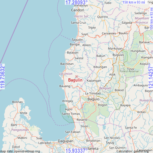
| Upper-left | 17.28093°, | 119.73632° |
| Center: | 16.60833°, | 120.43944° |
| Lower-right: | 15.93337°, | 121.14257° |
| Map W x H: | 149.8×149.8 km | = 93.1×93.1mi |
| max Lat: | 20.78733° ⇑8.5% North |
| Bagulin: | 16.60833° |
| min Lat: | ⇓91.5% South 4.65442° |
| min Long | Bagulin | max Long |
| 117.04868° | 120.43944° | 126.58417° |
| W 7.5%⇐ | ⇒92.5% E |
Elevation
Elevation of Bagulin is 67 m = 220 ft, and this is 20.9 m = 69 ft below average elevation for this country.
| Max E: |
2262 m = 7421 ft | 25.4% |
| Avg. | 87.9 m = 288 ft | |
| Bagulin | 67 m = 220 ft | |
Min E: |
-2 m = -7 ft | 74.6% |
See also: Philippines elevation on elevation.city.
Geographical zone
Bagulin is located in North Torrid zone (between Equator and Tropic of Cancer). Distance of this Northern Tropic circle is 759.2 km =471.7 mi to North.| Distance of | km | miles | from Bagulin |
|---|---|---|---|
| North Pole | 8160.4 | 5070.6 | to North |
| Arctic Circle | 5554.5 | 3451.4 | to North |
| Tropic Cancer | 759.2 | 471.7 | to North |
| Equator | 1846.7 | 1147.5 | to South |


Nearby cities:
15 places around Bagulin: (largest is in red/bold)
• Acao
11.4 km =7.1 mi,  216°
216°
• Bacnotan
15.7 km =9.8 mi,  323°
323°
• Bauang
14.2 km =8.8 mi,  232°
232°
• Bayabas
19.4 km =12.1 mi,  154°
154°
• Burgos
10.3 km =6.4 mi,  165°
165°
• Dagup
3.3 km =2.1 mi,  11°
11°
• Kapangan
17.2 km =10.7 mi,  102°
102°
• Naguilian
9.4 km =5.8 mi,  208°
208°
• Paringao
12.9 km =8 mi,  251°
251°
• Payocpoc Sur
17.4 km =10.8 mi, 223°
• Sablan
14.1 km =8.8 mi,  155°
155°
• San Fernando
13.1 km =8.1 mi,  273°
273°
• San Gabriel
8.4 km =5.2 mi,  332°
332°
• San Juan
12.4 km =7.7 mi,  302°
302°
• Santol
18.3 km =11.4 mi, 6°
Sources, notices
• [Note1] Compared only with cities in Philippines existing in our database
• [Src1] Map data: © OpenStreetMap contributors (CC-BY-SA)
• [Src2] Other city data from geonames.org with taken over terms of usage.
• [Src3] Geographical zone / Annual Mean Temperature by Robert A. Rohde @ Wikipedia
