Perez geodata
Perez (Calabarzon) is a seat of a third-order administrative division; located in Philippines in Asia/Manila (GMT+8) time zone. With population of 4,788 people, there are 1381 cities with bigger population in this country. Compared to other cities in Philippines, 71.8% of cities are located further ↓South; 61.2% of cities are located further →East and 67.4% of cities have higher elevation than Perez. Note1


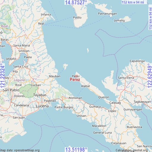
Perez GPS coordinates[2]
14° 11' 40.74" North, 121° 55' 34.896" East
| Map corner | latitude | longitude |
|---|---|---|
| Upper-left | 14.87527°, | 121.22324° |
| Center: | 14.19465°, | 121.92636° |
| Lower-right: | 13.51198°, | 122.62949° |
| Map W x H: | 151.6×151.6 km | = 94.2×94.2mi |
| max Lat: | 20.78733° ⇑28.2% North |
| Perez: | 14.19465° |
| min Lat: | ⇓71.8% South 4.65442° |
| min Long | Perez | max Long |
| 117.04868° | 121.92636° | 126.58417° |
| W 38.8%⇐ | ⇒61.2% E |
Elevation
Elevation of Perez is 13 m = 43 ft, and this is 74.9 m = 246 ft below average elevation for this country.
| Max E: |
2262 m = 7421 ft | 67.4% |
| Avg. | 87.9 m = 288 ft | |
| Perez | 13 m = 43 ft | |
Min E: |
-2 m = -7 ft | 32.6% |
See also: Philippines elevation on elevation.city.
Geographical zone
Perez is located in North Torrid zone (between Equator and Tropic of Cancer). Distance of this Northern Tropic circle is 1027.6 km =638.5 mi to North.| Distance of | km | miles | from Perez |
|---|---|---|---|
| North Pole | 8428.8 | 5237.4 | to North |
| Arctic Circle | 5822.9 | 3618.2 | to North |
| Tropic Cancer | 1027.6 | 638.5 | to North |
| Equator | 1578.3 | 980.7 | to South |


Nearby cities:
15 places around Perez: (largest is in red/bold)
• Agdangan
35.3 km =21.9 mi,  182°
182°
• Alabat
14 km =8.7 mi,  138°
138°
• Atimonan
21.4 km =13.3 mi, 181°
• Binahaan
29.2 km =18.1 mi,  219°
219°
• Cagsiay
19.2 km =11.9 mi,  277°
277°
• Mainit Norte
7.1 km =4.4 mi,  117°
117°
• Malicboy
28 km =17.4 mi,  212°
212°
• Malinao Ilaya
24.1 km =15 mi,  203°
203°
• Marao
33.1 km =20.6 mi, 199°
• Mauban
21.1 km =13.1 mi,  268°
268°
• Padre Burgos
32.7 km =20.3 mi, 202°
• Plaridel
28.5 km =17.7 mi,  159°
159°
• Quezon
34.8 km =21.6 mi,  127°
127°
• Sampaloc
31.1 km =19.3 mi,  263°
263°
• Santa Cecilia
31.3 km =19.4 mi,  108°
108°
Sources, notices
• [Note1] Compared only with cities in Philippines existing in our database
• [Src1] Map data: © OpenStreetMap contributors (CC-BY-SA)
• [Src2] Other city data from geonames.org with taken over terms of usage.
• [Src3] Geographical zone / Annual Mean Temperature by Robert A. Rohde @ Wikipedia
