Puerto Princesa geodata
Puerto Princesa (Mimaropa) is a populated place; located in Philippines in Asia/Manila (GMT+8) time zone. With population of 222,673 people, there are 45 cities with bigger population in this country. Compared to other cities in Philippines, 71.3% of cities are located further ↑North; 99.2% of cities are located further →East and 54.5% of cities have higher elevation than Puerto Princesa. Note1
Administrative division(s):
- Level 1: Mimaropa
- Level 2: Province of Palawan
- Level 3: Puerto Princesa City


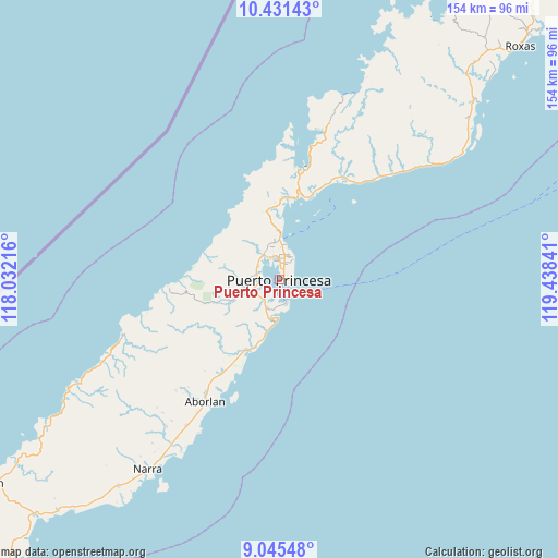
Puerto Princesa GPS coordinates[2]
9° 44' 21.012" North, 118° 44' 7.008" East
| Map corner | latitude | longitude |
|---|---|---|
| Upper-left | 10.43143°, | 118.03216° |
| Center: | 9.73917°, | 118.73528° |
| Lower-right: | 9.04548°, | 119.43841° |
| Map W x H: | 154.1×154.1 km | = 95.8×95.8mi |
| max Lat: | 20.78733° ⇑71.3% North |
| Puerto Princesa: | 9.73917° |
| min Lat: | ⇓28.7% South 4.65442° |
| min Long | Puerto Princesa | max Long |
| 117.04868° | 118.73528° | 126.58417° |
| W 0.8%⇐ | ⇒99.2% E |
Elevation
Elevation of Puerto Princesa is 20 m = 66 ft, and this is 67.9 m = 223 ft below average elevation for this country.
| Max E: |
2262 m = 7421 ft | 54.5% |
| Avg. | 87.9 m = 288 ft | |
| Puerto Princesa | 20 m = 66 ft | |
Min E: |
-2 m = -7 ft | 45.5% |
See also: Puerto Princesa elevation on elevation.city.
Geographical zone
Puerto Princesa is located in North Torrid zone (between Equator and Tropic of Cancer). Distance of Equator is 1082.9 km =672.9 mi to South.| Distance of | km | miles | from Puerto Princesa |
|---|---|---|---|
| North Pole | 8924.2 | 5545.2 | to North |
| Arctic Circle | 6318.3 | 3926 | to North |
| Tropic Cancer | 1523 | 946.3 | to North |
| Equator | 1082.9 | 672.9 | to South |


Nearby cities:
15 places around Puerto Princesa: (largest is in red/bold)
• Aborlan
39.7 km =24.7 mi,  211°
211°
• Apurawan
45.1 km =28 mi,  249°
249°
• Aramawayan
76.8 km =47.7 mi,  234°
234°
• Bacungan
19.4 km =12.1 mi,  349°
349°
• Baheli
30.8 km =19.1 mi,  7°
7°
• Calatugas
84.7 km =52.6 mi,  221°
221°
• Caramay
73.7 km =45.8 mi,  48°
48°
• Caruray
70.3 km =43.7 mi,  25°
25°
• Irahuan
9 km =5.6 mi,  328°
328°
• Isugod
80.7 km =50.1 mi,  236°
236°
• Narra
63.7 km =39.6 mi, 214°
• Panacan
65.5 km =40.7 mi, 213°
• Plaridel
47.6 km =29.6 mi, 212°
• San Jose
7.2 km =4.5 mi,  19°
19°
• Tagburos
10 km =6.2 mi,  357°
357°
Sources, notices
• [Note1] Compared only with cities in Philippines existing in our database
• [Src1] Map data: © OpenStreetMap contributors (CC-BY-SA)
• [Src2] Other city data from geonames.org with taken over terms of usage.
• [Src3] Geographical zone / Annual Mean Temperature by Robert A. Rohde @ Wikipedia
