Almeria geodata
Almeria (Eastern Visayas) is a seat of a third-order administrative division; located in Philippines in Asia/Manila (GMT+8) time zone. With population of 2,960 people, there are 2578 cities with bigger population in this country. Compared to other cities in Philippines, 50.1% of cities are located further ↑North; 77.1% of cities are located further ←West and 76.6% of cities have higher elevation than Almeria. Note1


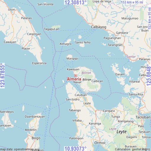
Almeria GPS coordinates[2]
11° 37' 13.008" North, 124° 22' 54.012" East
| Map corner | latitude | longitude |
|---|---|---|
| Upper-left | 12.30813°, | 123.67855° |
| Center: | 11.62028°, | 124.38167° |
| Lower-right: | 10.93073°, | 125.0848° |
| Map W x H: | 153.2×153.2 km | = 95.2×95.2mi |
| max Lat: | 20.78733° ⇑50.1% North |
| Almeria: | 11.62028° |
| min Lat: | ⇓49.9% South 4.65442° |
| min Long | Almeria | max Long |
| 117.04868° | 124.38167° | 126.58417° |
| W 77.1%⇐ | ⇒22.9% E |
Elevation
Elevation of Almeria is 10 m = 33 ft, and this is 77.9 m = 256 ft below average elevation for this country.
| Max E: |
2262 m = 7421 ft | 76.6% |
| Avg. | 87.9 m = 288 ft | |
| Almeria | 10 m = 33 ft | |
Min E: |
-2 m = -7 ft | 23.4% |
See also: Philippines elevation on elevation.city.
Geographical zone
Almeria is located in North Torrid zone (between Equator and Tropic of Cancer). Distance of Equator is 1292.1 km =802.9 mi to South.| Distance of | km | miles | from Almeria |
|---|---|---|---|
| North Pole | 8715 | 5415.2 | to North |
| Arctic Circle | 6109.1 | 3796 | to North |
| Tropic Cancer | 1313.9 | 816.4 | to North |
| Equator | 1292.1 | 802.9 | to South |


Nearby cities:
15 places around Almeria: (largest is in red/bold)
• Balagui
23 km =14.3 mi,  134°
134°
• Biliran
19.8 km =12.3 mi,  149°
149°
• Caibiran
22.5 km =14 mi,  103°
103°
• Calubian
19.9 km =12.4 mi,  165°
165°
• Caraycaray
8.1 km =5 mi, 153°
• Catmon
10.9 km =6.8 mi, 150°
• Culaba
18 km =11.2 mi,  76°
76°
• Kawayan
7.1 km =4.4 mi,  337°
337°
• Looc
24.5 km =15.2 mi, 129°
• Maripipi
18 km =11.2 mi,  348°
348°
• Naval
6.9 km =4.3 mi, 165°
• Palaroo
26.3 km =16.3 mi,  155°
155°
• San Isidro
24 km =14.9 mi,  187°
187°
• Tabing
24.7 km =15.3 mi, 188°
• Tucdao
13.3 km =8.3 mi,  47°
47°
Sources, notices
• [Note1] Compared only with cities in Philippines existing in our database
• [Src1] Map data: © OpenStreetMap contributors (CC-BY-SA)
• [Src2] Other city data from geonames.org with taken over terms of usage.
• [Src3] Geographical zone / Annual Mean Temperature by Robert A. Rohde @ Wikipedia
