Shahpur Chakar geodata
Shahpur Chakar (Sindh) is a populated place; located in Pakistan in Asia/Karachi (GMT+5) time zone. With population of 21,446 people, there are 265 cities with bigger population in this country. Compared to other cities in Pakistan, 86.5% of cities are located further ↑North; 75.2% of cities are located further →East and 89.6% of cities have higher elevation than Shahpur Chakar. Note1


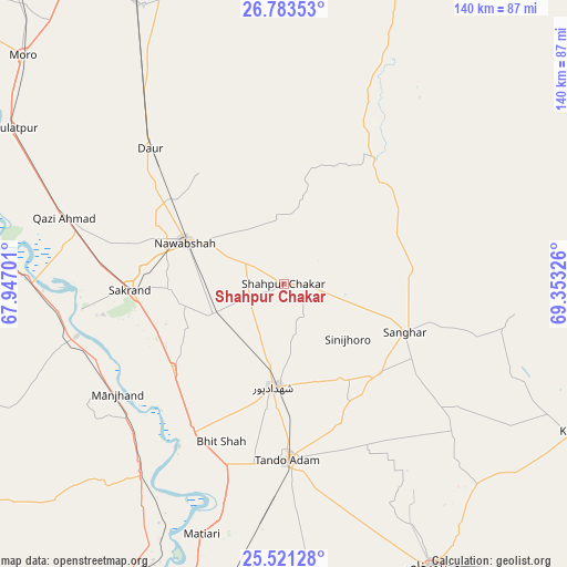
Shahpur Chakar GPS coordinates[2]
26° 9' 14.796" North, 68° 39' 0.468" East
| Map corner | latitude | longitude |
|---|---|---|
| Upper-left | 26.78353°, | 67.94701° |
| Center: | 26.15411°, | 68.65013° |
| Lower-right: | 25.52128°, | 69.35326° |
| Map W x H: | 140.3×140.4 km | = 87.2×87.2mi |
| max Lat: | 36.32162° ⇑86.5% North |
| Shahpur Chakar: | 26.15411° |
| min Lat: | ⇓13.5% South 24.14422° |
| min Long | Shahpur Chakar | max Long |
| 61.74573° | 68.65013° | 75.63372° |
| W 24.8%⇐ | ⇒75.2% E |
Elevation
Elevation of Shahpur Chakar is 29 m = 95 ft, and this is 316 m = 1037 ft below average elevation for this country.
| Max E: |
2732 m = 8963 ft | 89.6% |
| Avg. | 345 m = 1132 ft | |
| Shahpur Chakar | 29 m = 95 ft | |
Min E: |
3 m = 10 ft | 10.4% |
See also: Pakistan elevation on elevation.city.
Geographical zone
Shahpur Chakar is located in North temperate zone (between Tropic of Cancer and the Arctic Circle). Distance of this Northern Tropic circle is 302.1 km =187.7 mi to South.| Distance of | km | miles | from Shahpur Chakar |
|---|---|---|---|
| North Pole | 7099 | 4411.1 | to North |
| Arctic Circle | 4493.1 | 2791.9 | to North |
| Tropic Cancer | 302.1 | 187.7 | to South |
| Equator | 2908.1 | 1807 | to South |


Nearby cities:
15 places around Shahpur Chakar: (largest is in red/bold)
• Berani
44 km =27.3 mi,  159°
159°
• Bhit Shah
41.9 km =26 mi,  202°
202°
• Daur
47.1 km =29.3 mi,  315°
315°
• Hala
44.1 km =27.4 mi,  211°
211°
• Jhol
32.5 km =20.2 mi,  132°
132°
• Jām Sāhib
15.9 km =9.9 mi,  352°
352°
• Khadro
6.8 km =4.2 mi,  96°
96°
• Nawabshah
26.4 km =16.4 mi,  291°
291°
• Sakrand
37.5 km =23.3 mi,  267°
267°
• Sanghar
32.1 km =19.9 mi,  111°
111°
• Sann
52.7 km =32.7 mi,  256°
256°
• Shahdadpur
25.6 km =15.9 mi,  186°
186°
• Sinjhoro
21 km =13 mi, 131°
• Tando Adam
42.9 km =26.7 mi,  178°
178°
• Tando Mitha Khan
57.9 km =36 mi, 107°
Sources, notices
• [Note1] Compared only with cities in Pakistan existing in our database
• [Src1] Map data: © OpenStreetMap contributors (CC-BY-SA)
• [Src2] Other city data from geonames.org with taken over terms of usage.
• [Src3] Geographical zone / Annual Mean Temperature by Robert A. Rohde @ Wikipedia
