Hala geodata
Hala (Sindh) is a populated place; located in Pakistan in Asia/Karachi (GMT+5) time zone. With population of 47,915 people, there are 134 cities with bigger population in this country. Compared to other cities in Pakistan, 88.7% of cities are located further ↑North; 79.9% of cities are located further →East and 88.9% of cities have higher elevation than Hala. Note1


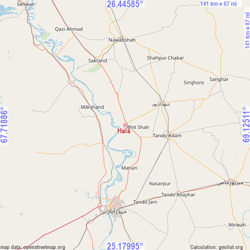
Hala GPS coordinates[2]
25° 48' 52.524" North, 68° 25' 19.128" East
| Map corner | latitude | longitude |
|---|---|---|
| Upper-left | 26.44585°, | 67.71886° |
| Center: | 25.81459°, | 68.42198° |
| Lower-right: | 25.17995°, | 69.12511° |
| Map W x H: | 140.8×140.8 km | = 87.5×87.5mi |
| max Lat: | 36.32162° ⇑88.7% North |
| Hala: | 25.81459° |
| min Lat: | ⇓11.3% South 24.14422° |
| min Long | Hala | max Long |
| 61.74573° | 68.42198° | 75.63372° |
| W 20.1%⇐ | ⇒79.9% E |
Elevation
Elevation of Hala is 30 m = 98 ft, and this is 315 m = 1033 ft below average elevation for this country.
| Max E: |
2732 m = 8963 ft | 88.9% |
| Avg. | 345 m = 1132 ft | |
| Hala | 30 m = 98 ft | |
Min E: |
3 m = 10 ft | 11.1% |
See also: Hala elevation on elevation.city.
Geographical zone
Hala is located in North temperate zone (between Tropic of Cancer and the Arctic Circle). Distance of this Northern Tropic circle is 264.4 km =164.3 mi to South.| Distance of | km | miles | from Hala |
|---|---|---|---|
| North Pole | 7136.7 | 4434.5 | to North |
| Arctic Circle | 4530.9 | 2815.4 | to North |
| Tropic Cancer | 264.4 | 164.3 | to South |
| Equator | 2870.3 | 1783.5 | to South |


Nearby cities:
15 places around Hala: (largest is in red/bold)
• Berani
38.7 km =24 mi,  94°
94°
• Bhit Shah
7 km =4.3 mi,  98°
98°
• Hyderabad
47.2 km =29.3 mi,  185°
185°
• Jamshoro
44.4 km =27.6 mi,  198°
198°
• Jhol
49.2 km =30.6 mi,  71°
71°
• Khadro
47.3 km =29.4 mi,  38°
38°
• Matiari
24.3 km =15.1 mi,  174°
174°
• Nawabshah
47.3 km =29.4 mi,  357°
357°
• Sakrand
38.9 km =24.2 mi,  337°
337°
• Sann
37.9 km =23.5 mi,  311°
311°
• Shahdadpur
23.6 km =14.7 mi,  58°
58°
• Shahpur Chakar
44.1 km =27.4 mi,  31°
31°
• Sinjhoro
45.5 km =28.3 mi, 58°
• Tando Adam
24.6 km =15.3 mi, 102°
• Tando Jam
44.3 km =27.5 mi, 165°
Sources, notices
• [Note1] Compared only with cities in Pakistan existing in our database
• [Src1] Map data: © OpenStreetMap contributors (CC-BY-SA)
• [Src2] Other city data from geonames.org with taken over terms of usage.
• [Src3] Geographical zone / Annual Mean Temperature by Robert A. Rohde @ Wikipedia
