Shahdadpur geodata
Shahdadpur (Sindh) is a populated place; located in Pakistan in Asia/Karachi (GMT+5) time zone. With population of 67,249 people, there are 104 cities with bigger population in this country. Compared to other cities in Pakistan, 88.5% of cities are located further ↑North; 76.1% of cities are located further →East and 88.9% of cities have higher elevation than Shahdadpur. Note1


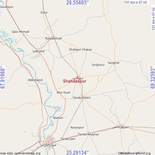
Shahdadpur GPS coordinates[2]
25° 55' 31.404" North, 68° 37' 22.08" East
| Map corner | latitude | longitude |
|---|---|---|
| Upper-left | 26.55605°, | 67.91968° |
| Center: | 25.92539°, | 68.6228° |
| Lower-right: | 25.29134°, | 69.32593° |
| Map W x H: | 140.6×140.6 km | = 87.4×87.4mi |
| max Lat: | 36.32162° ⇑88.5% North |
| Shahdadpur: | 25.92539° |
| min Lat: | ⇓11.5% South 24.14422° |
| min Long | Shahdadpur | max Long |
| 61.74573° | 68.6228° | 75.63372° |
| W 23.9%⇐ | ⇒76.1% E |
Elevation
Elevation of Shahdadpur is 30 m = 98 ft, and this is 315 m = 1033 ft below average elevation for this country.
| Max E: |
2732 m = 8963 ft | 88.9% |
| Avg. | 345 m = 1132 ft | |
| Shahdadpur | 30 m = 98 ft | |
Min E: |
3 m = 10 ft | 11.1% |
See also: Shahdadpur elevation on elevation.city.
Geographical zone
Shahdadpur is located in North temperate zone (between Tropic of Cancer and the Arctic Circle). Distance of this Northern Tropic circle is 276.7 km =171.9 mi to South.| Distance of | km | miles | from Shahdadpur |
|---|---|---|---|
| North Pole | 7124.4 | 4426.9 | to North |
| Arctic Circle | 4518.5 | 2807.7 | to North |
| Tropic Cancer | 276.7 | 171.9 | to South |
| Equator | 2882.6 | 1791.2 | to South |


Nearby cities:
15 places around Shahdadpur: (largest is in red/bold)
• Berani
24.2 km =15 mi,  130°
130°
• Bhit Shah
18.7 km =11.6 mi,  224°
224°
• Hala
23.6 km =14.7 mi,  238°
238°
• Jhol
26.8 km =16.7 mi,  82°
82°
• Jām Sāhib
41.2 km =25.6 mi,  0°
0°
• Khadro
26.4 km =16.4 mi,  21°
21°
• Matiari
40.5 km =25.2 mi,  205°
205°
• Nawabshah
41.2 km =25.6 mi,  327°
327°
• Sakrand
42.1 km =26.2 mi,  304°
304°
• Sanghar
35.3 km =21.9 mi,  67°
67°
• Sann
50.1 km =31.1 mi,  284°
284°
• Shahpur Chakar
25.6 km =15.9 mi,  6°
6°
• Sinjhoro
21.9 km =13.6 mi,  57°
57°
• Tando Adam
17.9 km =11.1 mi,  167°
167°
• Tando Allahyar
52.6 km =32.7 mi, 169°
Sources, notices
• [Note1] Compared only with cities in Pakistan existing in our database
• [Src1] Map data: © OpenStreetMap contributors (CC-BY-SA)
• [Src2] Other city data from geonames.org with taken over terms of usage.
• [Src3] Geographical zone / Annual Mean Temperature by Robert A. Rohde @ Wikipedia
