Sanghar geodata
Sanghar (Sindh) is a seat of a second-order administrative division; located in Pakistan in Asia/Karachi (GMT+5) time zone. With population of 62,033 people, there are 116 cities with bigger population in this country. Compared to other cities in Pakistan, 87.1% of cities are located further ↑North; 70.4% of cities are located further →East and 90.3% of cities have higher elevation than Sanghar. Note1


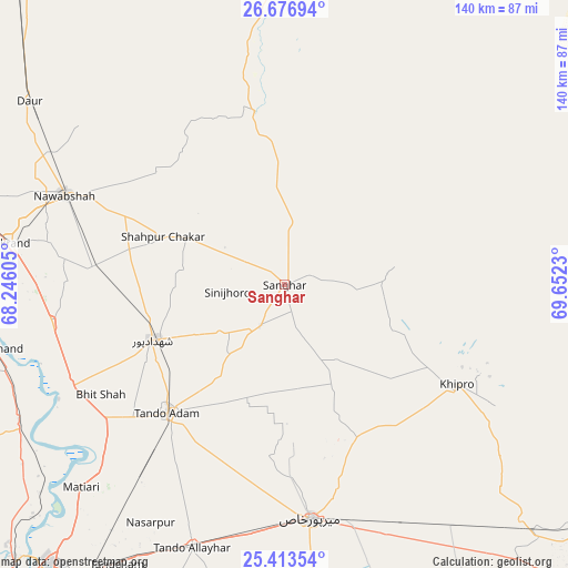
Sanghar GPS coordinates[2]
26° 2' 48.984" North, 68° 56' 57.012" East
| Map corner | latitude | longitude |
|---|---|---|
| Upper-left | 26.67694°, | 68.24605° |
| Center: | 26.04694°, | 68.94917° |
| Lower-right: | 25.41354°, | 69.6523° |
| Map W x H: | 140.5×140.5 km | = 87.3×87.3mi |
| max Lat: | 36.32162° ⇑87.1% North |
| Sanghar: | 26.04694° |
| min Lat: | ⇓12.9% South 24.14422° |
| min Long | Sanghar | max Long |
| 61.74573° | 68.94917° | 75.63372° |
| W 29.6%⇐ | ⇒70.4% E |
Elevation
Elevation of Sanghar is 26 m = 85 ft, and this is 319 m = 1047 ft below average elevation for this country.
| Max E: |
2732 m = 8963 ft | 90.3% |
| Avg. | 345 m = 1132 ft | |
| Sanghar | 26 m = 85 ft | |
Min E: |
3 m = 10 ft | 9.7% |
See also: Sanghar elevation on elevation.city.
Geographical zone
Sanghar is located in North temperate zone (between Tropic of Cancer and the Arctic Circle). Distance of this Northern Tropic circle is 290.2 km =180.3 mi to South.| Distance of | km | miles | from Sanghar |
|---|---|---|---|
| North Pole | 7110.9 | 4418.5 | to North |
| Arctic Circle | 4505 | 2799.3 | to North |
| Tropic Cancer | 290.2 | 180.3 | to South |
| Equator | 2896.1 | 1799.6 | to South |


Nearby cities:
15 places around Sanghar: (largest is in red/bold)
• Berani
32.4 km =20.1 mi,  205°
205°
• Bhit Shah
53.1 km =33 mi,  239°
239°
• Hala
58.7 km =36.5 mi, 243°
• Jhol
11.8 km =7.3 mi, 210°
• Jām Sāhib
42.3 km =26.3 mi,  310°
310°
• Khadro
25.7 km =16 mi,  295°
295°
• Mirpur Khas
58.1 km =36.1 mi,  173°
173°
• Nawabshah
58.5 km =36.4 mi,  291°
291°
• Sakrand
68.1 km =42.3 mi,  278°
278°
• Shahdadpur
35.3 km =21.9 mi,  247°
247°
• Shahpur Chakar
32.1 km =19.9 mi, 291°
• Sinjhoro
14.2 km =8.8 mi,  262°
262°
• Tando Adam
42.3 km =26.3 mi,  222°
222°
• Tando Allahyar
69.2 km =43 mi,  199°
199°
• Tando Mitha Khan
25.9 km =16.1 mi,  102°
102°
Sources, notices
• [Note1] Compared only with cities in Pakistan existing in our database
• [Src1] Map data: © OpenStreetMap contributors (CC-BY-SA)
• [Src2] Other city data from geonames.org with taken over terms of usage.
• [Src3] Geographical zone / Annual Mean Temperature by Robert A. Rohde @ Wikipedia
