Khadro geodata
Khadro (Sindh) is a populated place; located in Pakistan in Asia/Karachi (GMT+5) time zone. With population of 9,997 people, there are 352 cities with bigger population in this country. Compared to other cities in Pakistan, 86.7% of cities are located further ↑North; 73.8% of cities are located further →East and 89.6% of cities have higher elevation than Khadro. Note1


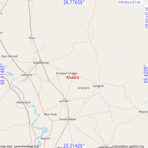
Khadro GPS coordinates[2]
26° 8' 49.668" North, 68° 43' 3.972" East
| Map corner | latitude | longitude |
|---|---|---|
| Upper-left | 26.77658°, | 68.01465° |
| Center: | 26.14713°, | 68.71777° |
| Lower-right: | 25.51426°, | 69.4209° |
| Map W x H: | 140.4×140.4 km | = 87.2×87.2mi |
| max Lat: | 36.32162° ⇑86.7% North |
| Khadro: | 26.14713° |
| min Lat: | ⇓13.3% South 24.14422° |
| min Long | Khadro | max Long |
| 61.74573° | 68.71777° | 75.63372° |
| W 26.2%⇐ | ⇒73.8% E |
Elevation
Elevation of Khadro is 29 m = 95 ft, and this is 316 m = 1037 ft below average elevation for this country.
| Max E: |
2732 m = 8963 ft | 89.6% |
| Avg. | 345 m = 1132 ft | |
| Khadro | 29 m = 95 ft | |
Min E: |
3 m = 10 ft | 10.4% |
See also: Pakistan elevation on elevation.city.
Geographical zone
Khadro is located in North temperate zone (between Tropic of Cancer and the Arctic Circle). Distance of this Northern Tropic circle is 301.4 km =187.3 mi to South.| Distance of | km | miles | from Khadro |
|---|---|---|---|
| North Pole | 7099.8 | 4411.6 | to North |
| Arctic Circle | 4493.9 | 2792.4 | to North |
| Tropic Cancer | 301.4 | 187.3 | to South |
| Equator | 2907.3 | 1806.5 | to South |


Nearby cities:
15 places around Khadro: (largest is in red/bold)
• Berani
41.3 km =25.7 mi,  167°
167°
• Bhit Shah
44.2 km =27.5 mi,  210°
210°
• Daur
52.5 km =32.6 mi,  310°
310°
• Hala
47.3 km =29.4 mi,  218°
218°
• Jhol
27.3 km =17 mi,  141°
141°
• Jām Sāhib
18.7 km =11.6 mi,  331°
331°
• Nawabshah
33 km =20.5 mi,  288°
288°
• Sakrand
44.3 km =27.5 mi,  268°
268°
• Sanghar
25.7 km =16 mi,  115°
115°
• Sann
59.1 km =36.7 mi,  258°
258°
• Shahdadpur
26.4 km =16.4 mi,  201°
201°
• Shahpur Chakar
6.8 km =4.2 mi,  276°
276°
• Sinjhoro
15.9 km =9.9 mi,  145°
145°
• Tando Adam
42.5 km =26.4 mi,  187°
187°
• Tando Mitha Khan
51.2 km =31.8 mi,  109°
109°
Sources, notices
• [Note1] Compared only with cities in Pakistan existing in our database
• [Src1] Map data: © OpenStreetMap contributors (CC-BY-SA)
• [Src2] Other city data from geonames.org with taken over terms of usage.
• [Src3] Geographical zone / Annual Mean Temperature by Robert A. Rohde @ Wikipedia
