Sinjhoro geodata
Sinjhoro (Sindh) is a populated place; located in Pakistan in Asia/Karachi (GMT+5) time zone. With population of 15,970 people, there are 305 cities with bigger population in this country. Compared to other cities in Pakistan, 87.6% of cities are located further ↑North; 72.5% of cities are located further →East and 91% of cities have higher elevation than Sinjhoro. Note1


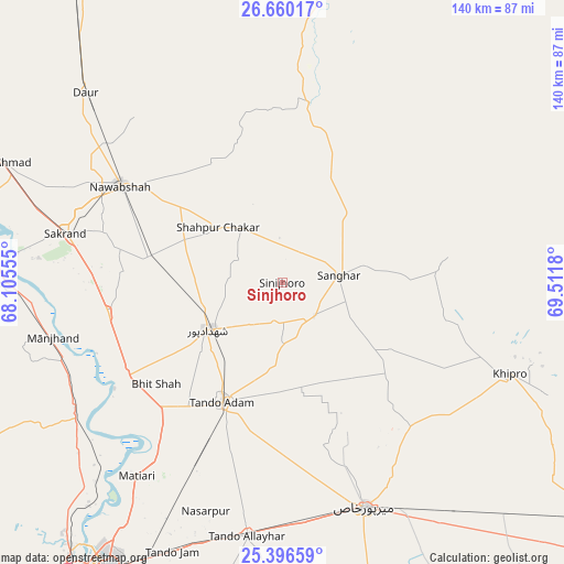
Sinjhoro GPS coordinates[2]
26° 1' 48.288" North, 68° 48' 31.212" East
| Map corner | latitude | longitude |
|---|---|---|
| Upper-left | 26.66017°, | 68.10555° |
| Center: | 26.03008°, | 68.80867° |
| Lower-right: | 25.39659°, | 69.5118° |
| Map W x H: | 140.5×140.5 km | = 87.3×87.3mi |
| max Lat: | 36.32162° ⇑87.6% North |
| Sinjhoro: | 26.03008° |
| min Lat: | ⇓12.4% South 24.14422° |
| min Long | Sinjhoro | max Long |
| 61.74573° | 68.80867° | 75.63372° |
| W 27.5%⇐ | ⇒72.5% E |
Elevation
Elevation of Sinjhoro is 25 m = 82 ft, and this is 320 m = 1050 ft below average elevation for this country.
| Max E: |
2732 m = 8963 ft | 91% |
| Avg. | 345 m = 1132 ft | |
| Sinjhoro | 25 m = 82 ft | |
Min E: |
3 m = 10 ft | 9% |
See also: Pakistan elevation on elevation.city.
Geographical zone
Sinjhoro is located in North temperate zone (between Tropic of Cancer and the Arctic Circle). Distance of this Northern Tropic circle is 288.4 km =179.2 mi to South.| Distance of | km | miles | from Sinjhoro |
|---|---|---|---|
| North Pole | 7112.8 | 4419.7 | to North |
| Arctic Circle | 4506.9 | 2800.5 | to North |
| Tropic Cancer | 288.4 | 179.2 | to South |
| Equator | 2894.3 | 1798.4 | to South |


Nearby cities:
15 places around Sinjhoro: (largest is in red/bold)
• Berani
27.3 km =17 mi,  180°
180°
• Bhit Shah
40.4 km =25.1 mi,  231°
231°
• Hala
45.5 km =28.3 mi,  238°
238°
• Jhol
11.5 km =7.1 mi,  136°
136°
• Jām Sāhib
34.6 km =21.5 mi,  328°
328°
• Khadro
15.9 km =9.9 mi, 325°
• Matiari
60.3 km =37.5 mi,  216°
216°
• Mirpur Khas
59.5 km =37 mi,  159°
159°
• Nawabshah
46.6 km =29 mi,  299°
299°
• Sakrand
54.7 km =34 mi,  282°
282°
• Sanghar
14.2 km =8.8 mi,  82°
82°
• Shahdadpur
21.9 km =13.6 mi, 237°
• Shahpur Chakar
21 km =13 mi,  311°
311°
• Tando Adam
32.6 km =20.3 mi,  206°
206°
• Tando Mitha Khan
39.5 km =24.5 mi,  95°
95°
Sources, notices
• [Note1] Compared only with cities in Pakistan existing in our database
• [Src1] Map data: © OpenStreetMap contributors (CC-BY-SA)
• [Src2] Other city data from geonames.org with taken over terms of usage.
• [Src3] Geographical zone / Annual Mean Temperature by Robert A. Rohde @ Wikipedia
