Bhit Shah geodata
Bhit Shah (Sindh) is a populated place; located in Pakistan in Asia/Karachi (GMT+5) time zone. With population of 19,325 people, there are 276 cities with bigger population in this country. Compared to other cities in Pakistan, 89.2% of cities are located further ↑North; 78.8% of cities are located further →East and 88.3% of cities have higher elevation than Bhit Shah. Note1


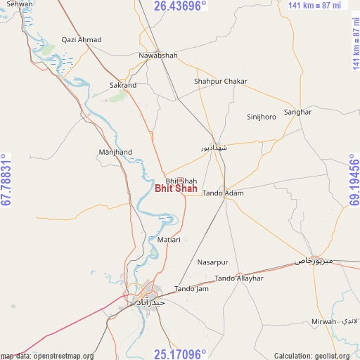
Bhit Shah GPS coordinates[2]
25° 48' 20.34" North, 68° 29' 29.148" East
| Map corner | latitude | longitude |
|---|---|---|
| Upper-left | 26.43696°, | 67.78831° |
| Center: | 25.80565°, | 68.49143° |
| Lower-right: | 25.17096°, | 69.19456° |
| Map W x H: | 140.8×140.8 km | = 87.5×87.5mi |
| max Lat: | 36.32162° ⇑89.2% North |
| Bhit Shah: | 25.80565° |
| min Lat: | ⇓10.8% South 24.14422° |
| min Long | Bhit Shah | max Long |
| 61.74573° | 68.49143° | 75.63372° |
| W 21.2%⇐ | ⇒78.8% E |
Elevation
Elevation of Bhit Shah is 31 m = 102 ft, and this is 314 m = 1030 ft below average elevation for this country.
| Max E: |
2732 m = 8963 ft | 88.3% |
| Avg. | 345 m = 1132 ft | |
| Bhit Shah | 31 m = 102 ft | |
Min E: |
3 m = 10 ft | 11.7% |
See also: Pakistan elevation on elevation.city.
Geographical zone
Bhit Shah is located in North temperate zone (between Tropic of Cancer and the Arctic Circle). Distance of this Northern Tropic circle is 263.4 km =163.7 mi to South.| Distance of | km | miles | from Bhit Shah |
|---|---|---|---|
| North Pole | 7137.7 | 4435.2 | to North |
| Arctic Circle | 4531.9 | 2816 | to North |
| Tropic Cancer | 263.4 | 163.7 | to South |
| Equator | 2869.3 | 1782.9 | to South |


Nearby cities:
15 places around Bhit Shah: (largest is in red/bold)
• Berani
31.7 km =19.7 mi,  94°
94°
• Hala
7 km =4.3 mi,  278°
278°
• Hyderabad
47.4 km =29.5 mi,  194°
194°
• Jamshoro
46.2 km =28.7 mi,  207°
207°
• Jhol
43.1 km =26.8 mi,  67°
67°
• Khadro
44.2 km =27.5 mi,  30°
30°
• Matiari
23.6 km =14.7 mi, 190°
• Sakrand
42.9 km =26.7 mi,  329°
329°
• Sann
44 km =27.3 mi,  306°
306°
• Shahdadpur
18.7 km =11.6 mi,  44°
44°
• Shahpur Chakar
41.9 km =26 mi,  22°
22°
• Sinjhoro
40.4 km =25.1 mi,  51°
51°
• Tando Adam
17.6 km =10.9 mi,  103°
103°
• Tando Allahyar
44.6 km =27.7 mi,  149°
149°
• Tando Jam
42.1 km =26.2 mi,  174°
174°
Sources, notices
• [Note1] Compared only with cities in Pakistan existing in our database
• [Src1] Map data: © OpenStreetMap contributors (CC-BY-SA)
• [Src2] Other city data from geonames.org with taken over terms of usage.
• [Src3] Geographical zone / Annual Mean Temperature by Robert A. Rohde @ Wikipedia
