Sillanwali geodata
Sillanwali (Punjab) is a populated place; located in Pakistan in Asia/Karachi (GMT+5) time zone. With population of 27,023 people, there are 226 cities with bigger population in this country. Compared to other cities in Pakistan, 63% of cities are located further ↓South; 65.7% of cities are located further ←West and 51% of cities have lower elevation than Sillanwali. Note1


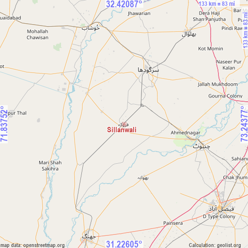
Sillanwali GPS coordinates[2]
31° 49' 31.404" North, 72° 32' 26.304" East
| Map corner | latitude | longitude |
|---|---|---|
| Upper-left | 32.42087°, | 71.83752° |
| Center: | 31.82539°, | 72.54064° |
| Lower-right: | 31.22605°, | 73.24377° |
| Map W x H: | 132.9×132.9 km | = 82.6×82.6mi |
| max Lat: | 36.32162° ⇑37% North |
| Sillanwali: | 31.82539° |
| min Lat: | ⇓63% South 24.14422° |
| min Long | Sillanwali | max Long |
| 61.74573° | 72.54064° | 75.63372° |
| W 65.7%⇐ | ⇒34.3% E |
Elevation
Elevation of Sillanwali is 182 m = 597 ft, and this is 163 m = 535 ft below average elevation for this country.
| Max E: |
2732 m = 8963 ft | 49% |
| Avg. | 345 m = 1132 ft | |
| Sillanwali | 182 m = 597 ft | |
Min E: |
3 m = 10 ft | 51% |
See also: Pakistan elevation on elevation.city.
Geographical zone
Sillanwali is located in North temperate zone (between Tropic of Cancer and the Arctic Circle). Distance of this Northern Tropic circle is 932.7 km =579.6 mi to South.| Distance of | km | miles | from Sillanwali |
|---|---|---|---|
| North Pole | 6468.4 | 4019.3 | to North |
| Arctic Circle | 3862.5 | 2400 | to North |
| Tropic Cancer | 932.7 | 579.6 | to South |
| Equator | 3538.7 | 2198.8 | to South |


Nearby cities:
15 places around Sillanwali: (largest is in red/bold)
• Bhalwal
59.4 km =36.9 mi,  34°
34°
• Bhawana
30.3 km =18.8 mi,  160°
160°
• Chenab Nagar
36.1 km =22.4 mi,  102°
102°
• Chiniot
43 km =26.7 mi,  105°
105°
• Faruka
13.8 km =8.6 mi,  299°
299°
• Jahanian Shah
25 km =15.5 mi,  264°
264°
• Jauharabad
57.1 km =35.5 mi,  334°
334°
• Keshupur
48.5 km =30.1 mi,  355°
355°
• Khushāb
55.3 km =34.4 mi,  341°
341°
• Lalian
24.6 km =15.3 mi,  90°
90°
• Liliani
57.2 km =35.5 mi,  42°
42°
• Mangla
16.8 km =10.4 mi, 296°
• Sahiwal
25.8 km =16 mi,  309°
309°
• Sargodha
31.6 km =19.6 mi,  23°
23°
• Shahpur
49.7 km =30.9 mi,  352°
352°
Sources, notices
• [Note1] Compared only with cities in Pakistan existing in our database
• [Src1] Map data: © OpenStreetMap contributors (CC-BY-SA)
• [Src2] Other city data from geonames.org with taken over terms of usage.
• [Src3] Geographical zone / Annual Mean Temperature by Robert A. Rohde @ Wikipedia
