Ladhewala Waraich geodata
Ladhewala Waraich (Punjab) is a section of populated place; located in Pakistan in Asia/Karachi (GMT+5) time zone. With population of 39,757 people, there are 157 cities with bigger population in this country. Compared to other cities in Pakistan, 68.2% of cities are located further ↓South; 91.4% of cities are located further ←West and 66.1% of cities have lower elevation than Ladhewala Waraich. Note1


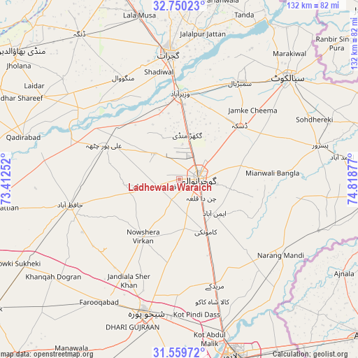
Ladhewala Waraich GPS coordinates[2]
32° 9' 24.912" North, 74° 6' 56.304" East
| Map corner | latitude | longitude |
|---|---|---|
| Upper-left | 32.75023°, | 73.41252° |
| Center: | 32.15692°, | 74.11564° |
| Lower-right: | 31.55972°, | 74.81877° |
| Map W x H: | 132.4×132.4 km | = 82.3×82.3mi |
| max Lat: | 36.32162° ⇑31.8% North |
| Ladhewala Waraich: | 32.15692° |
| min Lat: | ⇓68.2% South 24.14422° |
| min Long | Ladhewala Warai | max Long |
| 61.74573° | 74.11564° | 75.63372° |
| W 91.4%⇐ | ⇒8.6% E |
Elevation
Elevation of Ladhewala Waraich is 228 m = 748 ft, and this is 117 m = 384 ft below average elevation for this country.
| Max E: |
2732 m = 8963 ft | 33.9% |
| Avg. | 345 m = 1132 ft | |
| Ladhewala Waraich | 228 m = 748 ft | |
Min E: |
3 m = 10 ft | 66.1% |
See also: Pakistan elevation on elevation.city.
Geographical zone
Ladhewala Waraich is located in North temperate zone (between Tropic of Cancer and the Arctic Circle). Distance of this Northern Tropic circle is 969.6 km =602.5 mi to South.| Distance of | km | miles | from Ladhewala Waraich |
|---|---|---|---|
| North Pole | 6431.5 | 3996.3 | to North |
| Arctic Circle | 3825.7 | 2377.2 | to North |
| Tropic Cancer | 969.6 | 602.5 | to South |
| Equator | 3575.5 | 2221.7 | to South |


Nearby cities:
15 places around Ladhewala Waraich: (largest is in red/bold)
• Begowala
34.4 km =21.4 mi,  24°
24°
• Bhopalwala
38.2 km =23.7 mi,  37°
37°
• Daska Kalan
28.9 km =18 mi,  49°
49°
• Dhaunkal
27.8 km =17.3 mi,  4°
4°
• Eminabad
18.6 km =11.6 mi,  133°
133°
• Gujranwala
6.7 km =4.2 mi,  91°
91°
• Hafizabad
41.4 km =25.7 mi,  256°
256°
• Jandiala Sher Khan
41.7 km =25.9 mi,  206°
206°
• Kamoke
22.6 km =14 mi,  153°
153°
• Muridke
41.6 km =25.8 mi,  161°
161°
• Naushahra Virkan
25.5 km =15.8 mi, 212°
• Rasulnagar
36.8 km =22.9 mi,  301°
301°
• Sambrial
42.1 km =26.2 mi,  32°
32°
• Sodhri
34.5 km =21.4 mi,  10°
10°
• Wazirabad
31.8 km =19.8 mi, 0°
Sources, notices
• [Note1] Compared only with cities in Pakistan existing in our database
• [Src1] Map data: © OpenStreetMap contributors (CC-BY-SA)
• [Src2] Other city data from geonames.org with taken over terms of usage.
• [Src3] Geographical zone / Annual Mean Temperature by Robert A. Rohde @ Wikipedia
