Wazirabad geodata
Wazirabad (Punjab) is a populated place; located in Pakistan in Asia/Karachi (GMT+5) time zone. With population of 102,444 people, there are 64 cities with bigger population in this country. Compared to other cities in Pakistan, 74.3% of cities are located further ↓South; 91.6% of cities are located further ←West and 67.5% of cities have lower elevation than Wazirabad. Note1


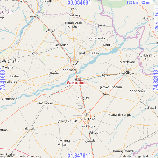
Wazirabad GPS coordinates[2]
32° 26' 35.664" North, 74° 7' 12" East
| Map corner | latitude | longitude |
|---|---|---|
| Upper-left | 33.03466°, | 73.41688° |
| Center: | 32.44324°, | 74.12° |
| Lower-right: | 31.84791°, | 74.82313° |
| Map W x H: | 132×132 km | = 82×82mi |
| max Lat: | 36.32162° ⇑25.7% North |
| Wazirabad: | 32.44324° |
| min Lat: | ⇓74.3% South 24.14422° |
| min Long | Wazirabad | max Long |
| 61.74573° | 74.12° | 75.63372° |
| W 91.6%⇐ | ⇒8.4% E |
Elevation
Elevation of Wazirabad is 231 m = 758 ft, and this is 114 m = 374 ft below average elevation for this country.
| Max E: |
2732 m = 8963 ft | 32.5% |
| Avg. | 345 m = 1132 ft | |
| Wazirabad | 231 m = 758 ft | |
Min E: |
3 m = 10 ft | 67.5% |
See also: Wazirabad elevation on elevation.city.
Geographical zone
Wazirabad is located in North temperate zone (between Tropic of Cancer and the Arctic Circle). Distance of this Northern Tropic circle is 1001.4 km =622.2 mi to South.| Distance of | km | miles | from Wazirabad |
|---|---|---|---|
| North Pole | 6399.7 | 3976.6 | to North |
| Arctic Circle | 3793.8 | 2357.4 | to North |
| Tropic Cancer | 1001.4 | 622.2 | to South |
| Equator | 3607.4 | 2241.5 | to South |


Nearby cities:
15 places around Wazirabad: (largest is in red/bold)
• Begowala
13.9 km =8.6 mi,  92°
92°
• Bhopalwala
22.9 km =14.2 mi, 93°
• Daska Kalan
25.4 km =15.8 mi,  121°
121°
• Dhaunkal
4.4 km =2.7 mi,  158°
158°
• Gujranwala
32.6 km =20.3 mi,  168°
168°
• Gujrat
15.1 km =9.4 mi,  343°
343°
• Jalalpur Jattan
23.4 km =14.5 mi,  20°
20°
• Kotli Loharan
38.7 km =24 mi,  65°
65°
• Kunjah
16.7 km =10.4 mi,  305°
305°
• Ladhewala Waraich
31.8 km =19.8 mi,  180°
180°
• Lala Musa
32.5 km =20.2 mi,  332°
332°
• Rasulnagar
34.4 km =21.4 mi,  248°
248°
• Sambrial
22.2 km =13.8 mi,  79°
79°
• Sialkot
39 km =24.2 mi, 81°
• Sodhri
6.2 km =3.9 mi, 70°
Sources, notices
• [Note1] Compared only with cities in Pakistan existing in our database
• [Src1] Map data: © OpenStreetMap contributors (CC-BY-SA)
• [Src2] Other city data from geonames.org with taken over terms of usage.
• [Src3] Geographical zone / Annual Mean Temperature by Robert A. Rohde @ Wikipedia
