Bhopalwala geodata
Bhopalwala (Punjab) is a populated place; located in Pakistan in Asia/Karachi (GMT+5) time zone. With population of 17,341 people, there are 289 cities with bigger population in this country. Compared to other cities in Pakistan, 73.6% of cities are located further ↓South; 95.3% of cities are located further ←West and 70.4% of cities have lower elevation than Bhopalwala. Note1


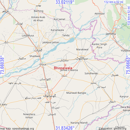
Bhopalwala GPS coordinates[2]
32° 25' 46.848" North, 74° 21' 48.6" East
| Map corner | latitude | longitude |
|---|---|---|
| Upper-left | 33.02119°, | 73.66038° |
| Center: | 32.42968°, | 74.3635° |
| Lower-right: | 31.83426°, | 75.06663° |
| Map W x H: | 132×132 km | = 82×82mi |
| max Lat: | 36.32162° ⇑26.4% North |
| Bhopalwala: | 32.42968° |
| min Lat: | ⇓73.6% South 24.14422° |
| min Long | Bhopalwala | max Long |
| 61.74573° | 74.3635° | 75.63372° |
| W 95.3%⇐ | ⇒4.7% E |
Elevation
Elevation of Bhopalwala is 245 m = 804 ft, and this is 100 m = 328 ft below average elevation for this country.
| Max E: |
2732 m = 8963 ft | 29.6% |
| Avg. | 345 m = 1132 ft | |
| Bhopalwala | 245 m = 804 ft | |
Min E: |
3 m = 10 ft | 70.4% |
See also: Pakistan elevation on elevation.city.
Geographical zone
Bhopalwala is located in North temperate zone (between Tropic of Cancer and the Arctic Circle). Distance of this Northern Tropic circle is 999.9 km =621.3 mi to South.| Distance of | km | miles | from Bhopalwala |
|---|---|---|---|
| North Pole | 6401.2 | 3977.5 | to North |
| Arctic Circle | 3795.3 | 2358.3 | to North |
| Tropic Cancer | 999.9 | 621.3 | to South |
| Equator | 3605.8 | 2240.5 | to South |


Nearby cities:
15 places around Bhopalwala: (largest is in red/bold)
• Begowala
9 km =5.6 mi,  276°
276°
• Chawinda
33.4 km =20.8 mi,  106°
106°
• Daska Kalan
11.8 km =7.3 mi,  185°
185°
• Dhaunkal
21.4 km =13.3 mi,  262°
262°
• Gujrat
31.4 km =19.5 mi,  300°
300°
• Hadali
30.3 km =18.8 mi,  39°
39°
• Jalalpur Jattan
27.8 km =17.3 mi,  327°
327°
• Kot Ghulam Muhammad
20.3 km =12.6 mi,  121°
121°
• Kot Rajkour
25 km =15.5 mi,  94°
94°
• Kotli Loharan
21.6 km =13.4 mi,  34°
34°
• Sambrial
5.5 km =3.4 mi,  350°
350°
• Sialkot
17.2 km =10.7 mi,  66°
66°
• Sodhri
17.4 km =10.8 mi, 281°
• Surkhpur
33 km =20.5 mi,  13°
13°
• Wazirabad
22.9 km =14.2 mi,  273°
273°
Sources, notices
• [Note1] Compared only with cities in Pakistan existing in our database
• [Src1] Map data: © OpenStreetMap contributors (CC-BY-SA)
• [Src2] Other city data from geonames.org with taken over terms of usage.
• [Src3] Geographical zone / Annual Mean Temperature by Robert A. Rohde @ Wikipedia
