Rasulnagar geodata
Rasulnagar (Punjab) is a populated place; located in Pakistan in Asia/Karachi (GMT+5) time zone. With population of 14,392 people, there are 322 cities with bigger population in this country. Compared to other cities in Pakistan, 72% of cities are located further ↓South; 86.5% of cities are located further ←West and 65.2% of cities have lower elevation than Rasulnagar. Note1


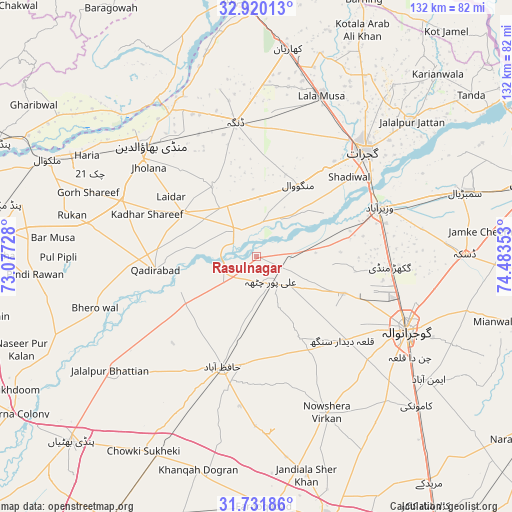
Rasulnagar GPS coordinates[2]
32° 19' 40.584" North, 73° 46' 49.44" East
| Map corner | latitude | longitude |
|---|---|---|
| Upper-left | 32.92013°, | 73.07728° |
| Center: | 32.32794°, | 73.7804° |
| Lower-right: | 31.73186°, | 74.48353° |
| Map W x H: | 132.1×132.1 km | = 82.1×82.1mi |
| max Lat: | 36.32162° ⇑28% North |
| Rasulnagar: | 32.32794° |
| min Lat: | ⇓72% South 24.14422° |
| min Long | Rasulnagar | max Long |
| 61.74573° | 73.7804° | 75.63372° |
| W 86.5%⇐ | ⇒13.5% E |
Elevation
Elevation of Rasulnagar is 220 m = 722 ft, and this is 125 m = 410 ft below average elevation for this country.
| Max E: |
2732 m = 8963 ft | 34.8% |
| Avg. | 345 m = 1132 ft | |
| Rasulnagar | 220 m = 722 ft | |
Min E: |
3 m = 10 ft | 65.2% |
See also: Pakistan elevation on elevation.city.
Geographical zone
Rasulnagar is located in North temperate zone (between Tropic of Cancer and the Arctic Circle). Distance of this Northern Tropic circle is 988.6 km =614.3 mi to South.| Distance of | km | miles | from Rasulnagar |
|---|---|---|---|
| North Pole | 6412.5 | 3984.5 | to North |
| Arctic Circle | 3806.6 | 2365.3 | to North |
| Tropic Cancer | 988.6 | 614.3 | to South |
| Equator | 3594.5 | 2233.5 | to South |


Nearby cities:
15 places around Rasulnagar: (largest is in red/bold)
• Begowala
47.4 km =29.5 mi,  75°
75°
• Dhaunkal
34.6 km =21.5 mi, 75°
• Dinga
35.3 km =21.9 mi,  350°
350°
• Gujranwala
42.8 km =26.6 mi,  116°
116°
• Gujrat
38.9 km =24.2 mi,  45°
45°
• Hafizabad
29.9 km =18.6 mi,  196°
196°
• Kaleke Mandi
42.7 km =26.5 mi, 203°
• Kunjah
28.9 km =18 mi,  39°
39°
• Ladhewala Waraich
36.8 km =22.9 mi, 121°
• Lala Musa
44.7 km =27.8 mi,  21°
21°
• Mandi Bahauddin
39.6 km =24.6 mi,  316°
316°
• Naushahra Virkan
44.4 km =27.6 mi,  156°
156°
• Phalia
22.1 km =13.7 mi,  301°
301°
• Sodhri
40.6 km =25.2 mi,  68°
68°
• Wazirabad
34.4 km =21.4 mi, 68°
Sources, notices
• [Note1] Compared only with cities in Pakistan existing in our database
• [Src1] Map data: © OpenStreetMap contributors (CC-BY-SA)
• [Src2] Other city data from geonames.org with taken over terms of usage.
• [Src3] Geographical zone / Annual Mean Temperature by Robert A. Rohde @ Wikipedia
